Higueruelas geodata
Higueruelas (Valencia) is a seat of a third-order administrative division; located in Spain in Europe/Madrid (GMT+2) time zone. With population of 519 people, there are 3818 cities with bigger population in this country. Compared to other cities in Spain, 73.1% of cities are located further ↑North; 78.3% of cities are located further ←West and 65% of cities have lower elevation than Higueruelas. Note1


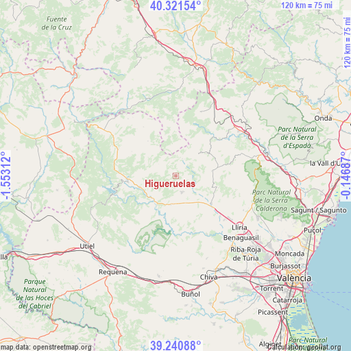
Higueruelas GPS coordinates[2]
39° 46' 59.988" North, 0° 51' 0" West
| Map corner | latitude | longitude |
|---|---|---|
| Upper-left | 40.32154°, | -1.55312° |
| Center: | 39.78333°, | -0.85° |
| Lower-right: | 39.24088°, | -0.14687° |
| Map W x H: | 120.2×120.2 km | = 74.7×74.7mi |
| max Lat: | 43.74134° ⇑73.1% North |
| Higueruelas: | 39.78333° |
| min Lat: | ⇓26.9% South 27.64134° |
| min Long | Higueruelas | max Long |
| -18.00367° | -0.85° | 4.2899° |
| W 78.3%⇐ | ⇒21.7% E |
Elevation
Elevation of Higueruelas is 778 m = 2552 ft, and this is 180 m = 591 ft above average elevation for this country.
| Max E: |
1682 m = 5518 ft | 35% |
| Higueruelas | 778 m 2552 ft | |
| Avg. | 598 m = 1962 ft | |
Min E: |
0 m = 0 ft | 65% |
See also: Spain elevation on elevation.city.
Geographical zone
Higueruelas is located in North temperate zone (between Tropic of Cancer and the Arctic Circle). Distance of this Northern Tropic circle is 1817.6 km =1129.4 mi to South.| Distance of | km | miles | from Higueruelas |
|---|---|---|---|
| North Pole | 5583.6 | 3469.5 | to North |
| Arctic Circle | 2977.7 | 1850.3 | to North |
| Tropic Cancer | 1817.6 | 1129.4 | to South |
| Equator | 4423.5 | 2748.6 | to South |


Nearby cities:
15 places around Higueruelas: (largest is in red/bold)
• Alcublas
12.9 km =8 mi,  81°
81°
• Alpuente
17 km =10.6 mi,  303°
303°
• Andilla
7 km =4.3 mi,  37°
37°
• Bugarra
19.9 km =12.4 mi,  158°
158°
• Calles
12.4 km =7.7 mi,  236°
236°
• Casinos
15.8 km =9.8 mi,  125°
125°
• Chelva
13.1 km =8.1 mi,  253°
253°
• Chulilla
15.1 km =9.4 mi,  190°
190°
• La Yesa
14 km =8.7 mi,  322°
322°
• Loriguilla
12.5 km =7.8 mi,  207°
207°
• Losa del Obispo
9.4 km =5.8 mi, 188°
• Sacañet
14.7 km =9.1 mi,  50°
50°
• Sot de Chera
17.2 km =10.7 mi, 194°
• Tuéjar
15.8 km =9.8 mi,  263°
263°
• Villar del Arzobispo
6.2 km =3.9 mi,  152°
152°
Sources, notices
• [Note1] Compared only with cities in Spain existing in our database
• [Src1] Map data: © OpenStreetMap contributors (CC-BY-SA)
• [Src2] Other city data from geonames.org with taken over terms of usage.
• [Src3] Geographical zone / Annual Mean Temperature by Robert A. Rohde @ Wikipedia
