Toril geodata
Toril (Extremadura) is a seat of a third-order administrative division; located in Spain in Europe/Madrid (GMT+2) time zone. With population of 231 people, there are 4855 cities with bigger population in this country. Compared to other cities in Spain, 71.7% of cities are located further ↑North; 82.9% of cities are located further →East and 77.9% of cities have higher elevation than Toril. Note1


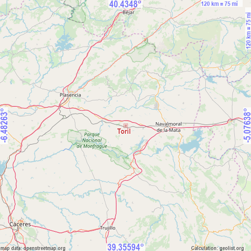
Toril GPS coordinates[2]
39° 53' 50.964" North, 5° 46' 46.2" West
| Map corner | latitude | longitude |
|---|---|---|
| Upper-left | 40.4348°, | -6.48263° |
| Center: | 39.89749°, | -5.7795° |
| Lower-right: | 39.35594°, | -5.07638° |
| Map W x H: | 120×120 km | = 74.6×74.6mi |
| max Lat: | 43.74134° ⇑71.7% North |
| Toril: | 39.89749° |
| min Lat: | ⇓28.3% South 27.64134° |
| min Long | Toril | max Long |
| -18.00367° | -5.7795° | 4.2899° |
| W 17.1%⇐ | ⇒82.9% E |
Elevation
Elevation of Toril is 258 m = 846 ft, and this is 340 m = 1115 ft below average elevation for this country.
| Max E: |
1682 m = 5518 ft | 77.9% |
| Avg. | 598 m = 1962 ft | |
| Toril | 258 m = 846 ft | |
Min E: |
0 m = 0 ft | 22.1% |
See also: Spain elevation on elevation.city.
Geographical zone
Toril is located in North temperate zone (between Tropic of Cancer and the Arctic Circle). Distance of this Northern Tropic circle is 1830.3 km =1137.3 mi to South.| Distance of | km | miles | from Toril |
|---|---|---|---|
| North Pole | 5570.9 | 3461.6 | to North |
| Arctic Circle | 2965 | 1842.4 | to North |
| Tropic Cancer | 1830.3 | 1137.3 | to South |
| Equator | 4436.2 | 2756.5 | to South |


Nearby cities:
15 places around Toril: (largest is in red/bold)
• Almaraz
12.7 km =7.9 mi,  136°
136°
• Arroyomolinos de la Vera
18.3 km =11.4 mi,  340°
340°
• Belvis de Monroy
17 km =10.6 mi,  120°
120°
• Casas de Miravete
19.2 km =11.9 mi,  170°
170°
• Casatejada
8.4 km =5.2 mi,  98°
98°
• Collado
18.5 km =11.5 mi,  15°
15°
• Jaraíz de la Vera
18.2 km =11.3 mi,  6°
6°
• Majadas
5.8 km =3.6 mi,  29°
29°
• Millanes
17.8 km =11.1 mi,  107°
107°
• Romangordo
18.6 km =11.6 mi,  158°
158°
• Saucedilla
10 km =6.2 mi, 119°
• Serrejón
9.1 km =5.7 mi,  192°
192°
• Talayuela
17.6 km =10.9 mi,  55°
55°
• Tejeda de Tiétar
15.4 km =9.6 mi,  330°
330°
• Torremenga
16.6 km =10.3 mi,  1°
1°
Sources, notices
• [Note1] Compared only with cities in Spain existing in our database
• [Src1] Map data: © OpenStreetMap contributors (CC-BY-SA)
• [Src2] Other city data from geonames.org with taken over terms of usage.
• [Src3] Geographical zone / Annual Mean Temperature by Robert A. Rohde @ Wikipedia
