Tejeda de Tiétar geodata
Tejeda de Tiétar (Extremadura) is a seat of a third-order administrative division; located in Spain in Europe/Madrid (GMT+2) time zone. With population of 979 people, there are 2982 cities with bigger population in this country. Compared to other cities in Spain, 69.9% of cities are located further ↑North; 84.2% of cities are located further →East and 66.6% of cities have higher elevation than Tejeda de Tiétar. Note1
Administrative division(s):
- Level 1: Extremadura
- Level 2: Provincia de Cáceres
- Level 3: Tejeda de Tiétar


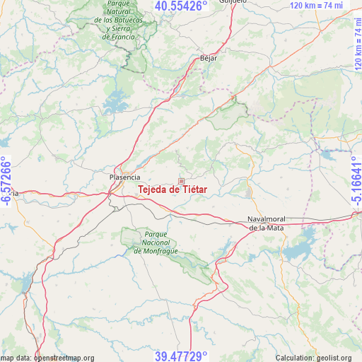
Tejeda de Tiétar GPS coordinates[2]
40° 1' 4.44" North, 5° 52' 10.308" West
| Map corner | latitude | longitude |
|---|---|---|
| Upper-left | 40.55426°, | -6.57266° |
| Center: | 40.0179°, | -5.86953° |
| Lower-right: | 39.47729°, | -5.16641° |
| Map W x H: | 119.7×119.7 km | = 74.4×74.4mi |
| max Lat: | 43.74134° ⇑69.9% North |
| Tejeda de Tiétar: | 40.0179° |
| min Lat: | ⇓30.1% South 27.64134° |
| min Long | Tejeda de Tiét | max Long |
| -18.00367° | -5.86953° | 4.2899° |
| W 15.8%⇐ | ⇒84.2% E |
Elevation
Elevation of Tejeda de Tiétar is 439 m = 1440 ft, and this is 159 m = 522 ft below average elevation for this country.
| Max E: |
1682 m = 5518 ft | 66.6% |
| Avg. | 598 m = 1962 ft | |
| Tejeda de Tiétar | 439 m = 1440 ft | |
Min E: |
0 m = 0 ft | 33.4% |
See also: Spain elevation on elevation.city.
Geographical zone
Tejeda de Tiétar is located in North temperate zone (between Tropic of Cancer and the Arctic Circle). Distance of this Northern Tropic circle is 1843.7 km =1145.6 mi to South.| Distance of | km | miles | from Tejeda de Tiétar |
|---|---|---|---|
| North Pole | 5557.5 | 3453.3 | to North |
| Arctic Circle | 2951.6 | 1834 | to North |
| Tropic Cancer | 1843.7 | 1145.6 | to South |
| Equator | 4449.6 | 2764.9 | to South |


Nearby cities:
15 places around Tejeda de Tiétar: (largest is in red/bold)
• Arroyomolinos de la Vera
4.2 km =2.6 mi,  22°
22°
• Barrado
7.5 km =4.7 mi,  352°
352°
• Cabrero
10.8 km =6.7 mi, 349°
• Casas del Castañar
10.4 km =6.5 mi,  343°
343°
• Collado
13.4 km =8.3 mi,  70°
70°
• El Torno
14.6 km =9.1 mi,  334°
334°
• Garganta la Olla
13 km =8.1 mi,  37°
37°
• Gargüera
6.9 km =4.3 mi,  314°
314°
• Jaraíz de la Vera
10.9 km =6.8 mi,  64°
64°
• Majadas
13.4 km =8.3 mi,  128°
128°
• Malpartida de Plasencia
15.6 km =9.7 mi,  254°
254°
• Piornal
11.2 km =7 mi,  9°
9°
• Toril
15.4 km =9.6 mi,  150°
150°
• Torremenga
8.7 km =5.4 mi, 68°
• Valdastillas
12.8 km =8 mi,  356°
356°
Sources, notices
• [Note1] Compared only with cities in Spain existing in our database
• [Src1] Map data: © OpenStreetMap contributors (CC-BY-SA)
• [Src2] Other city data from geonames.org with taken over terms of usage.
• [Src3] Geographical zone / Annual Mean Temperature by Robert A. Rohde @ Wikipedia
