Sedaví geodata
Sedaví (Valencia) is a seat of a third-order administrative division; located in Spain in Europe/Madrid (GMT+2) time zone. With population of 8,778 people, there are 899 cities with bigger population in this country. Compared to other cities in Spain, 77.5% of cities are located further ↑North; 83.3% of cities are located further ←West and 98.9% of cities have higher elevation than Sedaví. Note1


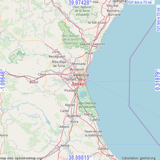
Sedaví GPS coordinates[2]
39° 25' 59.988" North, 0° 22' 59.988" West
| Map corner | latitude | longitude |
|---|---|---|
| Upper-left | 39.97428°, | -1.08646° |
| Center: | 39.43333°, | -0.38333° |
| Lower-right: | 38.88815°, | 0.31979° |
| Map W x H: | 120.8×120.8 km | = 75.1×75.1mi |
| max Lat: | 43.74134° ⇑77.5% North |
| Sedaví: | 39.43333° |
| min Lat: | ⇓22.5% South 27.64134° |
| min Long | Sedaví | max Long |
| -18.00367° | -0.38333° | 4.2899° |
| W 83.3%⇐ | ⇒16.7% E |
Elevation
Elevation of Sedaví is 8 m = 26 ft, and this is 590 m = 1936 ft below average elevation for this country.
| Max E: |
1682 m = 5518 ft | 98.9% |
| Avg. | 598 m = 1962 ft | |
| Sedaví | 8 m = 26 ft | |
Min E: |
0 m = 0 ft | 1.1% |
See also: Spain elevation on elevation.city.
Geographical zone
Sedaví is located in North temperate zone (between Tropic of Cancer and the Arctic Circle). Distance of this Northern Tropic circle is 1778.7 km =1105.2 mi to South.| Distance of | km | miles | from Sedaví |
|---|---|---|---|
| North Pole | 5622.5 | 3493.7 | to North |
| Arctic Circle | 3016.6 | 1874.4 | to North |
| Tropic Cancer | 1778.7 | 1105.2 | to South |
| Equator | 4384.6 | 2724.5 | to South |


Nearby cities:
15 places around Sedaví: (largest is in red/bold)
• Alaquàs
7.1 km =4.4 mi,  290°
290°
• Albal
4.7 km =2.9 mi,  217°
217°
• Aldaia
7.5 km =4.7 mi,  298°
298°
• Alfafar
1.9 km =1.2 mi,  180°
180°
• Benetússer
1.7 km =1.1 mi, 224°
• Beniparrell
6.3 km =3.9 mi,  207°
207°
• Catarroja
4 km =2.5 mi,  201°
201°
• Mislata
5.5 km =3.4 mi,  327°
327°
• Paiporta
3 km =1.9 mi,  258°
258°
• Picanya
4.3 km =2.7 mi,  270°
270°
• Quart de Poblet
7.2 km =4.5 mi,  318°
318°
• Tavernes Blanques
7.5 km =4.7 mi,  10°
10°
• Torrent
7.1 km =4.4 mi, 273°
• Valencia
4.1 km =2.5 mi, 7°
• Xirivella
5.1 km =3.2 mi,  314°
314°
Sources, notices
• [Note1] Compared only with cities in Spain existing in our database
• [Src1] Map data: © OpenStreetMap contributors (CC-BY-SA)
• [Src2] Other city data from geonames.org with taken over terms of usage.
• [Src3] Geographical zone / Annual Mean Temperature by Robert A. Rohde @ Wikipedia
