Beniparrell geodata
Beniparrell (Valencia) is a seat of a third-order administrative division; located in Spain in Europe/Madrid (GMT+2) time zone. With population of 1,780 people, there are 2298 cities with bigger population in this country. Compared to other cities in Spain, 77.9% of cities are located further ↑North; 82.9% of cities are located further ←West and 99.6% of cities have higher elevation than Beniparrell. Note1


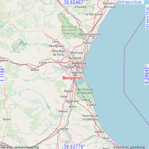
Beniparrell GPS coordinates[2]
39° 22' 59.988" North, 0° 25' 0.012" West
| Map corner | latitude | longitude |
|---|---|---|
| Upper-left | 39.92467°, | -1.1198° |
| Center: | 39.38333°, | -0.41667° |
| Lower-right: | 38.83776°, | 0.28645° |
| Map W x H: | 120.9×120.9 km | = 75.1×75.1mi |
| max Lat: | 43.74134° ⇑77.9% North |
| Beniparrell: | 39.38333° |
| min Lat: | ⇓22.1% South 27.64134° |
| min Long | Beniparrell | max Long |
| -18.00367° | -0.41667° | 4.2899° |
| W 82.9%⇐ | ⇒17.1% E |
Elevation
Elevation of Beniparrell is 5 m = 16 ft, and this is 593 m = 1946 ft below average elevation for this country.
| Max E: |
1682 m = 5518 ft | 99.6% |
| Avg. | 598 m = 1962 ft | |
| Beniparrell | 5 m = 16 ft | |
Min E: |
0 m = 0 ft | 0.4% |
See also: Spain elevation on elevation.city.
Geographical zone
Beniparrell is located in North temperate zone (between Tropic of Cancer and the Arctic Circle). Distance of this Northern Tropic circle is 1773.1 km =1101.8 mi to South.| Distance of | km | miles | from Beniparrell |
|---|---|---|---|
| North Pole | 5628 | 3497.1 | to North |
| Arctic Circle | 3022.2 | 1877.9 | to North |
| Tropic Cancer | 1773.1 | 1101.8 | to South |
| Equator | 4379 | 2721 | to South |


Nearby cities:
15 places around Beniparrell: (largest is in red/bold)
• Alaquàs
8.9 km =5.5 mi,  334°
334°
• Albal
1.9 km =1.2 mi,  0°
0°
• Alcàsser
2.9 km =1.8 mi,  234°
234°
• Aldaia
9.9 km =6.2 mi,  337°
337°
• Alfafar
4.7 km =2.9 mi,  37°
37°
• Benetússer
4.7 km =2.9 mi,  21°
21°
• Catarroja
2.3 km =1.4 mi, 37°
• Paiporta
5 km =3.1 mi,  359°
359°
• Picanya
5.7 km =3.5 mi,  345°
345°
• Picassent
4.3 km =2.7 mi,  239°
239°
• Sedaví
6.3 km =3.9 mi,  27°
27°
• Silla
2.3 km =1.4 mi,  169°
169°
• Torrent
7.3 km =4.5 mi,  324°
324°
• Valencia
10.2 km =6.3 mi, 19°
• Xirivella
9.2 km =5.7 mi, 355°
Sources, notices
• [Note1] Compared only with cities in Spain existing in our database
• [Src1] Map data: © OpenStreetMap contributors (CC-BY-SA)
• [Src2] Other city data from geonames.org with taken over terms of usage.
• [Src3] Geographical zone / Annual Mean Temperature by Robert A. Rohde @ Wikipedia
