Sayalonga geodata
Sayalonga (Andalusia) is a seat of a third-order administrative division; located in Spain in Europe/Madrid (GMT+2) time zone. With population of 1,366 people, there are 2579 cities with bigger population in this country. Compared to other cities in Spain, 96.8% of cities are located further ↑North; 59.9% of cities are located further →East and 72% of cities have higher elevation than Sayalonga. Note1


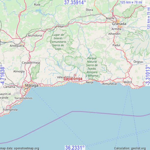
Sayalonga GPS coordinates[2]
36° 47' 53.484" North, 4° 0' 47.7" West
| Map corner | latitude | longitude |
|---|---|---|
| Upper-left | 37.35914°, | -4.71638° |
| Center: | 36.79819°, | -4.01325° |
| Lower-right: | 36.2331°, | -3.31013° |
| Map W x H: | 125.2×125.2 km | = 77.8×77.8mi |
| max Lat: | 43.74134° ⇑96.8% North |
| Sayalonga: | 36.79819° |
| min Lat: | ⇓3.2% South 27.64134° |
| min Long | Sayalonga | max Long |
| -18.00367° | -4.01325° | 4.2899° |
| W 40.1%⇐ | ⇒59.9% E |
Elevation
Elevation of Sayalonga is 347 m = 1138 ft, and this is 251 m = 823 ft below average elevation for this country.
| Max E: |
1682 m = 5518 ft | 72% |
| Avg. | 598 m = 1962 ft | |
| Sayalonga | 347 m = 1138 ft | |
Min E: |
0 m = 0 ft | 28% |
See also: Spain elevation on elevation.city.
Geographical zone
Sayalonga is located in North temperate zone (between Tropic of Cancer and the Arctic Circle). Distance of this Northern Tropic circle is 1485.7 km =923.2 mi to South.| Distance of | km | miles | from Sayalonga |
|---|---|---|---|
| North Pole | 5915.5 | 3675.7 | to North |
| Arctic Circle | 3309.6 | 2056.5 | to North |
| Tropic Cancer | 1485.7 | 923.2 | to South |
| Equator | 4091.6 | 2542.4 | to South |


Nearby cities:
15 places around Sayalonga: (largest is in red/bold)
• Algarrobo
3.6 km =2.2 mi,  220°
220°
• Arenas
3.4 km =2.1 mi,  306°
306°
• Benamocarra
13.2 km =8.2 mi,  266°
266°
• Canillas de Aceituno
10.4 km =6.5 mi,  323°
323°
• Canillas de Albaida
5.9 km =3.7 mi,  23°
23°
• Cómpeta
5.2 km =3.2 mi,  41°
41°
• Frigiliana
10.6 km =6.6 mi,  96°
96°
• Nerja
13.4 km =8.3 mi,  112°
112°
• Salares
6.4 km =4 mi,  351°
351°
• Sedella
7.3 km =4.5 mi, 346°
• Torre del Mar
9.5 km =5.9 mi,  228°
228°
• Torrox
7 km =4.3 mi,  129°
129°
• Viñuela
13.5 km =8.4 mi,  302°
302°
• Vélez-Málaga
8.2 km =5.1 mi,  256°
256°
• Árchez
5 km =3.1 mi, 22°
Sources, notices
• [Note1] Compared only with cities in Spain existing in our database
• [Src1] Map data: © OpenStreetMap contributors (CC-BY-SA)
• [Src2] Other city data from geonames.org with taken over terms of usage.
• [Src3] Geographical zone / Annual Mean Temperature by Robert A. Rohde @ Wikipedia
