Benamocarra geodata
Benamocarra (Andalusia) is a seat of a third-order administrative division; located in Spain in Europe/Madrid (GMT+2) time zone. With population of 2,904 people, there are 1755 cities with bigger population in this country. Compared to other cities in Spain, 96.9% of cities are located further ↑North; 62% of cities are located further →East and 85.3% of cities have higher elevation than Benamocarra. Note1


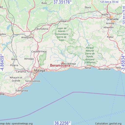
Benamocarra GPS coordinates[2]
36° 47' 26.7" North, 4° 9' 41.256" West
| Map corner | latitude | longitude |
|---|---|---|
| Upper-left | 37.35176°, | -4.86459° |
| Center: | 36.79075°, | -4.16146° |
| Lower-right: | 36.2256°, | -3.45834° |
| Map W x H: | 125.2×125.2 km | = 77.8×77.8mi |
| max Lat: | 43.74134° ⇑96.9% North |
| Benamocarra: | 36.79075° |
| min Lat: | ⇓3.1% South 27.64134° |
| min Long | Benamocarra | max Long |
| -18.00367° | -4.16146° | 4.2899° |
| W 38%⇐ | ⇒62% E |
Elevation
Elevation of Benamocarra is 134 m = 440 ft, and this is 464 m = 1522 ft below average elevation for this country.
| Max E: |
1682 m = 5518 ft | 85.3% |
| Avg. | 598 m = 1962 ft | |
| Benamocarra | 134 m = 440 ft | |
Min E: |
0 m = 0 ft | 14.7% |
See also: Spain elevation on elevation.city.
Geographical zone
Benamocarra is located in North temperate zone (between Tropic of Cancer and the Arctic Circle). Distance of this Northern Tropic circle is 1484.8 km =922.6 mi to South.| Distance of | km | miles | from Benamocarra |
|---|---|---|---|
| North Pole | 5916.3 | 3676.2 | to North |
| Arctic Circle | 3310.4 | 2057 | to North |
| Tropic Cancer | 1484.8 | 922.6 | to South |
| Equator | 4090.7 | 2541.8 | to South |


Nearby cities:
15 places around Benamocarra: (largest is in red/bold)
• Algarrobo
11 km =6.8 mi,  99°
99°
• Almáchar
5.3 km =3.3 mi,  292°
292°
• Arenas
10.8 km =6.7 mi,  74°
74°
• Benamargosa
5.7 km =3.5 mi,  329°
329°
• Borge
7.1 km =4.4 mi, 292°
• Canillas de Aceituno
11.5 km =7.1 mi,  37°
37°
• Comares
10 km =6.2 mi,  310°
310°
• Cútar
7.4 km =4.6 mi, 307°
• Iznate
2.1 km =1.3 mi,  247°
247°
• Moclinejo
8.6 km =5.3 mi,  255°
255°
• Torre del Mar
8.2 km =5.1 mi,  131°
131°
• Totalán
12.4 km =7.7 mi, 256°
• Valdés
8.1 km =5 mi,  243°
243°
• Viñuela
8.2 km =5.1 mi,  12°
12°
• Vélez-Málaga
5.3 km =3.3 mi, 101°
Sources, notices
• [Note1] Compared only with cities in Spain existing in our database
• [Src1] Map data: © OpenStreetMap contributors (CC-BY-SA)
• [Src2] Other city data from geonames.org with taken over terms of usage.
• [Src3] Geographical zone / Annual Mean Temperature by Robert A. Rohde @ Wikipedia
