Salteras geodata
Salteras (Andalusia) is a seat of a third-order administrative division; located in Spain in Europe/Madrid (GMT+2) time zone. With population of 3,814 people, there are 1512 cities with bigger population in this country. Compared to other cities in Spain, 91.7% of cities are located further ↑North; 87.5% of cities are located further →East and 84% of cities have higher elevation than Salteras. Note1


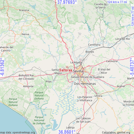
Salteras GPS coordinates[2]
37° 25' 14.16" North, 6° 6' 37.764" West
| Map corner | latitude | longitude |
|---|---|---|
| Upper-left | 37.97693°, | -6.81362° |
| Center: | 37.4206°, | -6.11049° |
| Lower-right: | 36.8601°, | -5.40737° |
| Map W x H: | 124.2×124.2 km | = 77.2×77.2mi |
| max Lat: | 43.74134° ⇑91.7% North |
| Salteras: | 37.4206° |
| min Lat: | ⇓8.3% South 27.64134° |
| min Long | Salteras | max Long |
| -18.00367° | -6.11049° | 4.2899° |
| W 12.5%⇐ | ⇒87.5% E |
Elevation
Elevation of Salteras is 156 m = 512 ft, and this is 442 m = 1450 ft below average elevation for this country.
| Max E: |
1682 m = 5518 ft | 84% |
| Avg. | 598 m = 1962 ft | |
| Salteras | 156 m = 512 ft | |
Min E: |
0 m = 0 ft | 16% |
See also: Spain elevation on elevation.city.
Geographical zone
Salteras is located in North temperate zone (between Tropic of Cancer and the Arctic Circle). Distance of this Northern Tropic circle is 1554.9 km =966.2 mi to South.| Distance of | km | miles | from Salteras |
|---|---|---|---|
| North Pole | 5846.3 | 3632.7 | to North |
| Arctic Circle | 3240.4 | 2013.5 | to North |
| Tropic Cancer | 1554.9 | 966.2 | to South |
| Equator | 4160.8 | 2585.4 | to South |


Nearby cities:
15 places around Salteras: (largest is in red/bold)
• Albaida del Aljarafe
5 km =3.1 mi,  273°
273°
• Bollullos de la Mitación
9.3 km =5.8 mi,  194°
194°
• Bormujos
6.2 km =3.9 mi,  147°
147°
• Camas
7.1 km =4.4 mi,  106°
106°
• Castilleja de Guzmán
5 km =3.1 mi,  104°
104°
• Castilleja de la Cuesta
6.4 km =4 mi,  126°
126°
• Espartinas
4.5 km =2.8 mi,  197°
197°
• Gines
4.8 km =3 mi,  142°
142°
• Olivares
4 km =2.5 mi, 265°
• Sanlúcar la Mayor
9 km =5.6 mi,  245°
245°
• Santiponce
6.4 km =4 mi,  74°
74°
• Tomares
7.8 km =4.8 mi, 132°
• Umbrete
7.2 km =4.5 mi,  216°
216°
• Valencina de la Concepción
3.2 km =2 mi, 98°
• Villanueva del Ariscal
3.8 km =2.4 mi, 224°
Sources, notices
• [Note1] Compared only with cities in Spain existing in our database
• [Src1] Map data: © OpenStreetMap contributors (CC-BY-SA)
• [Src2] Other city data from geonames.org with taken over terms of usage.
• [Src3] Geographical zone / Annual Mean Temperature by Robert A. Rohde @ Wikipedia
