Bollullos de la Mitación geodata
Bollullos de la Mitación (Andalusia) is a seat of a third-order administrative division; located in Spain in Europe/Madrid (GMT+2) time zone. With population of 6,499 people, there are 1085 cities with bigger population in this country. Compared to other cities in Spain, 92.6% of cities are located further ↑North; 87.8% of cities are located further →East and 88.5% of cities have higher elevation than Bollullos de la Mitación. Note1
Administrative division(s):
- Level 1: Andalusia
- Level 2: Provincia de Sevilla
- Level 3: Bollullos de la Mitación
Current local time in Bollullos de la Mitación:
09:35 PM, ThursdayDifference from your time zone: hours


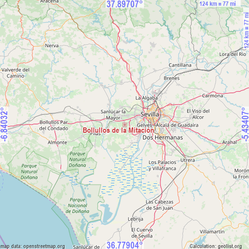
Bollullos de la Mitación GPS coordinates[2]
37° 20' 24.504" North, 6° 8' 13.884" West
| Map corner | latitude | longitude |
|---|---|---|
| Upper-left | 37.89707°, | -6.84032° |
| Center: | 37.34014°, | -6.13719° |
| Lower-right: | 36.77904°, | -5.43407° |
| Map W x H: | 124.3×124.3 km | = 77.2×77.2mi |
| max Lat: | 43.74134° ⇑92.6% North |
| Bollullos de la Mitación: | 37.34014° |
| min Lat: | ⇓7.4% South 27.64134° |
| min Long | Bollullos de la | max Long |
| -18.00367° | -6.13719° | 4.2899° |
| W 12.2%⇐ | ⇒87.8% E |
Elevation
Elevation of Bollullos de la Mitación is 87 m = 285 ft, and this is 511 m = 1677 ft below average elevation for this country.
| Max E: |
1682 m = 5518 ft | 88.5% |
| Avg. | 598 m = 1962 ft | |
| Bollullos de la Mitación | 87 m = 285 ft | |
Min E: |
0 m = 0 ft | 11.5% |
See also: Spain elevation on elevation.city.
Geographical zone
Bollullos de la Mitación is located in North temperate zone (between Tropic of Cancer and the Arctic Circle). Distance of this Northern Tropic circle is 1545.9 km =960.6 mi to South.| Distance of | km | miles | from Bollullos de la Mitación |
|---|---|---|---|
| North Pole | 5855.2 | 3638.3 | to North |
| Arctic Circle | 3249.3 | 2019 | to North |
| Tropic Cancer | 1545.9 | 960.6 | to South |
| Equator | 4151.8 | 2579.8 | to South |


Nearby cities:
15 places around Bollullos de la Mitación: (largest is in red/bold)
• Almensilla
4 km =2.5 mi,  143°
143°
• Benacazón
5.4 km =3.4 mi,  285°
285°
• Bormujos
6.8 km =4.2 mi,  57°
57°
• Castilleja de la Cuesta
9 km =5.6 mi, 55°
• Espartinas
4.7 km =2.9 mi,  12°
12°
• Gines
7.4 km =4.6 mi,  45°
45°
• Mairena del Aljarafe
6.5 km =4 mi,  85°
85°
• Olivares
8.8 km =5.5 mi,  349°
349°
• Palomares del Río
7.2 km =4.5 mi,  105°
105°
• Salteras
9.3 km =5.8 mi, 14°
• San Juan de Aznalfarache
9.1 km =5.7 mi,  77°
77°
• Sanlúcar la Mayor
7.9 km =4.9 mi,  312°
312°
• Tomares
8.8 km =5.5 mi,  65°
65°
• Umbrete
3.7 km =2.3 mi,  329°
329°
• Villanueva del Ariscal
6.2 km =3.9 mi,  357°
357°
Sources, notices
• [Note1] Compared only with cities in Spain existing in our database
• [Src1] Map data: © OpenStreetMap contributors (CC-BY-SA)
• [Src2] Other city data from geonames.org with taken over terms of usage.
• [Src3] Geographical zone / Annual Mean Temperature by Robert A. Rohde @ Wikipedia
