Tomares geodata
Tomares (Andalusia) is a seat of a third-order administrative division; located in Spain in Europe/Madrid (GMT+2) time zone. With population of 22,772 people, there are 409 cities with bigger population in this country. Compared to other cities in Spain, 92.2% of cities are located further ↑North; 86.6% of cities are located further →East and 89.3% of cities have higher elevation than Tomares. Note1


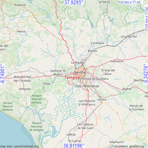
Tomares GPS coordinates[2]
37° 22' 22.116" North, 6° 2' 45.204" West
| Map corner | latitude | longitude |
|---|---|---|
| Upper-left | 37.9295°, | -6.74901° |
| Center: | 37.37281°, | -6.04589° |
| Lower-right: | 36.81196°, | -5.34276° |
| Map W x H: | 124.3×124.3 km | = 77.2×77.2mi |
| max Lat: | 43.74134° ⇑92.2% North |
| Tomares: | 37.37281° |
| min Lat: | ⇓7.8% South 27.64134° |
| min Long | Tomares | max Long |
| -18.00367° | -6.04589° | 4.2899° |
| W 13.4%⇐ | ⇒86.6% E |
Elevation
Elevation of Tomares is 76 m = 249 ft, and this is 522 m = 1713 ft below average elevation for this country.
| Max E: |
1682 m = 5518 ft | 89.3% |
| Avg. | 598 m = 1962 ft | |
| Tomares | 76 m = 249 ft | |
Min E: |
0 m = 0 ft | 10.7% |
See also: Spain elevation on elevation.city.
Geographical zone
Tomares is located in North temperate zone (between Tropic of Cancer and the Arctic Circle). Distance of this Northern Tropic circle is 1549.5 km =962.8 mi to South.| Distance of | km | miles | from Tomares |
|---|---|---|---|
| North Pole | 5851.6 | 3636 | to North |
| Arctic Circle | 3245.7 | 2016.8 | to North |
| Tropic Cancer | 1549.5 | 962.8 | to South |
| Equator | 4155.5 | 2582.1 | to South |


Nearby cities:
15 places around Tomares: (largest is in red/bold)
• Bollullos de la Mitación
8.8 km =5.5 mi,  245°
245°
• Bormujos
2.3 km =1.4 mi,  272°
272°
• Camas
3.4 km =2.1 mi,  19°
19°
• Castilleja de Guzmán
4.2 km =2.6 mi,  348°
348°
• Castilleja de la Cuesta
1.6 km =1 mi,  337°
337°
• Espartinas
7.1 km =4.4 mi,  277°
277°
• Gelves
4.6 km =2.9 mi,  157°
157°
• Gines
3.2 km =2 mi,  298°
298°
• Mairena del Aljarafe
3.5 km =2.2 mi,  206°
206°
• Palomares del Río
5.7 km =3.5 mi,  191°
191°
• Salteras
7.8 km =4.8 mi,  312°
312°
• San Juan de Aznalfarache
1.8 km =1.1 mi, 155°
• Santiponce
7 km =4.3 mi,  3°
3°
• Sevilla
6.5 km =4 mi,  80°
80°
• Valencina de la Concepción
5.4 km =3.4 mi,  332°
332°
Sources, notices
• [Note1] Compared only with cities in Spain existing in our database
• [Src1] Map data: © OpenStreetMap contributors (CC-BY-SA)
• [Src2] Other city data from geonames.org with taken over terms of usage.
• [Src3] Geographical zone / Annual Mean Temperature by Robert A. Rohde @ Wikipedia
