Rafelcofer geodata
Rafelcofer (Valencia) is a seat of a third-order administrative division; located in Spain in Europe/Madrid (GMT+2) time zone. With population of 1,395 people, there are 2549 cities with bigger population in this country. Compared to other cities in Spain, 81.8% of cities are located further ↑North; 85.8% of cities are located further ←West and 92.7% of cities have higher elevation than Rafelcofer. Note1


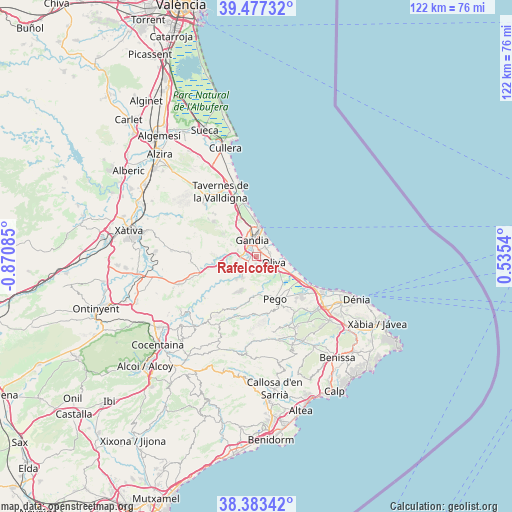
Rafelcofer GPS coordinates[2]
38° 55' 56.928" North, 0° 10' 3.792" West
| Map corner | latitude | longitude |
|---|---|---|
| Upper-left | 39.47732°, | -0.87085° |
| Center: | 38.93248°, | -0.16772° |
| Lower-right: | 38.38342°, | 0.5354° |
| Map W x H: | 121.6×121.6 km | = 75.6×75.6mi |
| max Lat: | 43.74134° ⇑81.8% North |
| Rafelcofer: | 38.93248° |
| min Lat: | ⇓18.2% South 27.64134° |
| min Long | Rafelcofer | max Long |
| -18.00367° | -0.16772° | 4.2899° |
| W 85.8%⇐ | ⇒14.2% E |
Elevation
Elevation of Rafelcofer is 40 m = 131 ft, and this is 558 m = 1831 ft below average elevation for this country.
| Max E: |
1682 m = 5518 ft | 92.7% |
| Avg. | 598 m = 1962 ft | |
| Rafelcofer | 40 m = 131 ft | |
Min E: |
0 m = 0 ft | 7.3% |
See also: Spain elevation on elevation.city.
Geographical zone
Rafelcofer is located in North temperate zone (between Tropic of Cancer and the Arctic Circle). Distance of this Northern Tropic circle is 1723 km =1070.6 mi to South.| Distance of | km | miles | from Rafelcofer |
|---|---|---|---|
| North Pole | 5678.2 | 3528.3 | to North |
| Arctic Circle | 3072.3 | 1909 | to North |
| Tropic Cancer | 1723 | 1070.6 | to South |
| Equator | 4328.9 | 2689.9 | to South |


Nearby cities:
15 places around Rafelcofer: (largest is in red/bold)
• Almoines
1.7 km =1.1 mi,  315°
315°
• Bellreguard
2 km =1.2 mi,  2°
2°
• Beniarjó
1.6 km =1 mi,  270°
270°
• Beniflá
1 km =0.6 mi,  241°
241°
• Benirredrà
4 km =2.5 mi,  340°
340°
• Daimús
4.1 km =2.5 mi,  21°
21°
• Gandia
4 km =2.5 mi, 340°
• L'Alqueria de la Comtessa
1.5 km =0.9 mi,  86°
86°
• Miramar
3.1 km =1.9 mi,  50°
50°
• Oliva
4.4 km =2.7 mi,  108°
108°
• Palma de Gandía
4.6 km =2.9 mi,  261°
261°
• Palmera
1.4 km =0.9 mi,  57°
57°
• Piles
3.2 km =2 mi,  71°
71°
• Potríes
3 km =1.9 mi,  233°
233°
• Real de Gandía
2.8 km =1.7 mi,  309°
309°
Sources, notices
• [Note1] Compared only with cities in Spain existing in our database
• [Src1] Map data: © OpenStreetMap contributors (CC-BY-SA)
• [Src2] Other city data from geonames.org with taken over terms of usage.
• [Src3] Geographical zone / Annual Mean Temperature by Robert A. Rohde @ Wikipedia
