Potríes geodata
Potríes (Valencia) is a seat of a third-order administrative division; located in Spain in Europe/Madrid (GMT+2) time zone. With population of 909 people, there are 3059 cities with bigger population in this country. Compared to other cities in Spain, 82% of cities are located further ↑North; 85.6% of cities are located further ←West and 90.2% of cities have higher elevation than Potríes. Note1


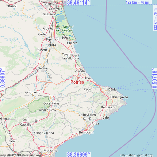
Potríes GPS coordinates[2]
38° 54' 58.212" North, 0° 11' 45.384" West
| Map corner | latitude | longitude |
|---|---|---|
| Upper-left | 39.46114°, | -0.89907° |
| Center: | 38.91617°, | -0.19594° |
| Lower-right: | 38.36699°, | 0.50718° |
| Map W x H: | 121.7×121.7 km | = 75.6×75.6mi |
| max Lat: | 43.74134° ⇑82% North |
| Potríes: | 38.91617° |
| min Lat: | ⇓18% South 27.64134° |
| min Long | Potríes | max Long |
| -18.00367° | -0.19594° | 4.2899° |
| W 85.6%⇐ | ⇒14.4% E |
Elevation
Elevation of Potríes is 63 m = 207 ft, and this is 535 m = 1755 ft below average elevation for this country.
| Max E: |
1682 m = 5518 ft | 90.2% |
| Avg. | 598 m = 1962 ft | |
| Potríes | 63 m = 207 ft | |
Min E: |
0 m = 0 ft | 9.8% |
See also: Spain elevation on elevation.city.
Geographical zone
Potríes is located in North temperate zone (between Tropic of Cancer and the Arctic Circle). Distance of this Northern Tropic circle is 1721.2 km =1069.5 mi to South.| Distance of | km | miles | from Potríes |
|---|---|---|---|
| North Pole | 5680 | 3529.4 | to North |
| Arctic Circle | 3074.1 | 1910.2 | to North |
| Tropic Cancer | 1721.2 | 1069.5 | to South |
| Equator | 4327.1 | 2688.7 | to South |


Nearby cities:
15 places around Potríes: (largest is in red/bold)
• Ador
2.3 km =1.4 mi,  275°
275°
• Alfauir
5.1 km =3.2 mi,  292°
292°
• Almoines
3.3 km =2.1 mi,  22°
22°
• Bellreguard
4.5 km =2.8 mi,  33°
33°
• Beniarjó
2 km =1.2 mi, 24°
• Beniflá
2 km =1.2 mi,  49°
49°
• Benirredrà
5.7 km =3.5 mi,  10°
10°
• Gandia
5.7 km =3.5 mi, 10°
• L'Alqueria de la Comtessa
4.4 km =2.7 mi,  64°
64°
• Palma de Gandía
2.4 km =1.5 mi,  299°
299°
• Palmera
4.4 km =2.7 mi, 54°
• Rafelcofer
3 km =1.9 mi, 53°
• Real de Gandía
3.6 km =2.2 mi,  4°
4°
• Rótova
5.6 km =3.5 mi, 288°
• Villalonga
3.5 km =2.2 mi,  197°
197°
Sources, notices
• [Note1] Compared only with cities in Spain existing in our database
• [Src1] Map data: © OpenStreetMap contributors (CC-BY-SA)
• [Src2] Other city data from geonames.org with taken over terms of usage.
• [Src3] Geographical zone / Annual Mean Temperature by Robert A. Rohde @ Wikipedia
