Miramar geodata
Miramar (Valencia) is a seat of a third-order administrative division; located in Spain in Europe/Madrid (GMT+2) time zone. With population of 1,675 people, there are 2355 cities with bigger population in this country. Compared to other cities in Spain, 81.5% of cities are located further ↑North; 86.1% of cities are located further ←West and 97.6% of cities have higher elevation than Miramar. Note1


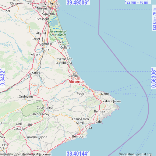
Miramar GPS coordinates[2]
38° 57' 1.296" North, 0° 8' 24.252" West
| Map corner | latitude | longitude |
|---|---|---|
| Upper-left | 39.49506°, | -0.8432° |
| Center: | 38.95036°, | -0.14007° |
| Lower-right: | 38.40144°, | 0.56306° |
| Map W x H: | 121.6×121.6 km | = 75.6×75.6mi |
| max Lat: | 43.74134° ⇑81.5% North |
| Miramar: | 38.95036° |
| min Lat: | ⇓18.5% South 27.64134° |
| min Long | Miramar | max Long |
| -18.00367° | -0.14007° | 4.2899° |
| W 86.1%⇐ | ⇒13.9% E |
Elevation
Elevation of Miramar is 13 m = 43 ft, and this is 585 m = 1919 ft below average elevation for this country.
| Max E: |
1682 m = 5518 ft | 97.6% |
| Avg. | 598 m = 1962 ft | |
| Miramar | 13 m = 43 ft | |
Min E: |
0 m = 0 ft | 2.4% |
See also: Spain elevation on elevation.city.
Geographical zone
Miramar is located in North temperate zone (between Tropic of Cancer and the Arctic Circle). Distance of this Northern Tropic circle is 1725 km =1071.9 mi to South.| Distance of | km | miles | from Miramar |
|---|---|---|---|
| North Pole | 5676.2 | 3527 | to North |
| Arctic Circle | 3070.3 | 1907.8 | to North |
| Tropic Cancer | 1725 | 1071.9 | to South |
| Equator | 4330.9 | 2691.1 | to South |


Nearby cities:
15 places around Miramar: (largest is in red/bold)
• Almoines
3.7 km =2.3 mi,  257°
257°
• Bellreguard
2.3 km =1.4 mi,  269°
269°
• Beniarjó
4.5 km =2.8 mi,  243°
243°
• Beniflá
4.1 km =2.5 mi,  233°
233°
• Benirredrà
4.2 km =2.6 mi,  295°
295°
• Daimús
2 km =1.2 mi,  334°
334°
• Gandia
4.2 km =2.6 mi, 295°
• L'Alqueria de la Comtessa
2.1 km =1.3 mi,  204°
204°
• Oliva
3.9 km =2.4 mi,  152°
152°
• Palma de Gandía
7.4 km =4.6 mi,  249°
249°
• Palmera
1.7 km =1.1 mi,  224°
224°
• Piles
1.2 km =0.7 mi, 147°
• Potríes
6.1 km =3.8 mi, 231°
• Rafelcofer
3.1 km =1.9 mi, 230°
• Real de Gandía
4.5 km =2.8 mi, 266°
Sources, notices
• [Note1] Compared only with cities in Spain existing in our database
• [Src1] Map data: © OpenStreetMap contributors (CC-BY-SA)
• [Src2] Other city data from geonames.org with taken over terms of usage.
• [Src3] Geographical zone / Annual Mean Temperature by Robert A. Rohde @ Wikipedia
