Planes geodata
Planes (Valencia) is a seat of a third-order administrative division; located in Spain in Europe/Madrid (GMT+2) time zone. With population of 798 people, there are 3213 cities with bigger population in this country. Compared to other cities in Spain, 83.4% of cities are located further ↑North; 84% of cities are located further ←West and 66.3% of cities have higher elevation than Planes. Note1


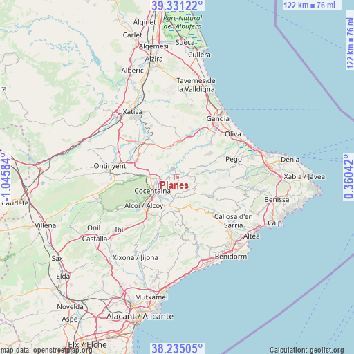
Planes GPS coordinates[2]
38° 47' 6.864" North, 0° 20' 33.756" West
| Map corner | latitude | longitude |
|---|---|---|
| Upper-left | 39.33122°, | -1.04584° |
| Center: | 38.78524°, | -0.34271° |
| Lower-right: | 38.23505°, | 0.36042° |
| Map W x H: | 121.9×121.9 km | = 75.7×75.7mi |
| max Lat: | 43.74134° ⇑83.4% North |
| Planes: | 38.78524° |
| min Lat: | ⇓16.6% South 27.64134° |
| min Long | Planes | max Long |
| -18.00367° | -0.34271° | 4.2899° |
| W 84%⇐ | ⇒16% E |
Elevation
Elevation of Planes is 443 m = 1453 ft, and this is 155 m = 509 ft below average elevation for this country.
| Max E: |
1682 m = 5518 ft | 66.3% |
| Avg. | 598 m = 1962 ft | |
| Planes | 443 m = 1453 ft | |
Min E: |
0 m = 0 ft | 33.7% |
See also: Spain elevation on elevation.city.
Geographical zone
Planes is located in North temperate zone (between Tropic of Cancer and the Arctic Circle). Distance of this Northern Tropic circle is 1706.6 km =1060.4 mi to South.| Distance of | km | miles | from Planes |
|---|---|---|---|
| North Pole | 5694.5 | 3538.4 | to North |
| Arctic Circle | 3088.7 | 1919.2 | to North |
| Tropic Cancer | 1706.6 | 1060.4 | to South |
| Equator | 4312.5 | 2679.7 | to South |


Nearby cities:
15 places around Planes: (largest is in red/bold)
• Alcocer de Planes
5.3 km =3.3 mi,  281°
281°
• Almudaina
2.9 km =1.8 mi,  195°
195°
• Balones
5.3 km =3.3 mi,  180°
180°
• Beniarrés
4.9 km =3 mi,  322°
322°
• Beniatjar
9.5 km =5.9 mi, 316°
• Benillup
4.7 km =2.9 mi,  222°
222°
• Benimarfull
4.3 km =2.7 mi,  256°
256°
• Benimassot
6.5 km =4 mi,  127°
127°
• Cocentaina
9.8 km =6.1 mi,  238°
238°
• Facheca
8.6 km =5.3 mi, 130°
• Gorga
7.5 km =4.7 mi,  188°
188°
• Millena
6.3 km =3.9 mi, 196°
• Muro del Alcoy
8.1 km =5 mi,  266°
266°
• Tollos
6.7 km =4.2 mi,  118°
118°
• Vall de Gallinera
9.7 km =6 mi,  64°
64°
Sources, notices
• [Note1] Compared only with cities in Spain existing in our database
• [Src1] Map data: © OpenStreetMap contributors (CC-BY-SA)
• [Src2] Other city data from geonames.org with taken over terms of usage.
• [Src3] Geographical zone / Annual Mean Temperature by Robert A. Rohde @ Wikipedia
