Cocentaina geodata
Cocentaina (Valencia) is a seat of a third-order administrative division; located in Spain in Europe/Madrid (GMT+2) time zone. With population of 11,467 people, there are 770 cities with bigger population in this country. Compared to other cities in Spain, 83.8% of cities are located further ↑North; 82.5% of cities are located further ←West and 65.1% of cities have higher elevation than Cocentaina. Note1


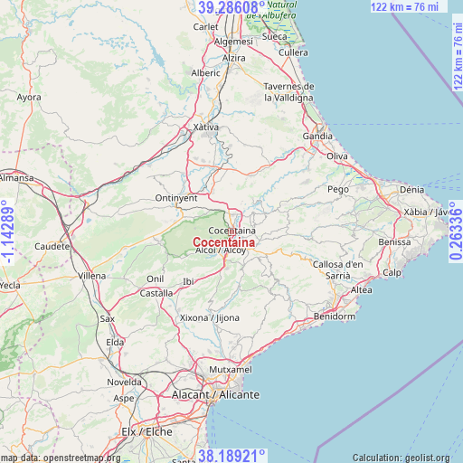
Cocentaina GPS coordinates[2]
38° 44' 23.1" North, 0° 26' 23.136" West
| Map corner | latitude | longitude |
|---|---|---|
| Upper-left | 39.28608°, | -1.14289° |
| Center: | 38.73975°, | -0.43976° |
| Lower-right: | 38.18921°, | 0.26336° |
| Map W x H: | 122×122 km | = 75.8×75.8mi |
| max Lat: | 43.74134° ⇑83.8% North |
| Cocentaina: | 38.73975° |
| min Lat: | ⇓16.2% South 27.64134° |
| min Long | Cocentaina | max Long |
| -18.00367° | -0.43976° | 4.2899° |
| W 82.5%⇐ | ⇒17.5% E |
Elevation
Elevation of Cocentaina is 458 m = 1503 ft, and this is 140 m = 459 ft below average elevation for this country.
| Max E: |
1682 m = 5518 ft | 65.1% |
| Avg. | 598 m = 1962 ft | |
| Cocentaina | 458 m = 1503 ft | |
Min E: |
0 m = 0 ft | 34.9% |
See also: Spain elevation on elevation.city.
Geographical zone
Cocentaina is located in North temperate zone (between Tropic of Cancer and the Arctic Circle). Distance of this Northern Tropic circle is 1701.5 km =1057.3 mi to South.| Distance of | km | miles | from Cocentaina |
|---|---|---|---|
| North Pole | 5699.6 | 3541.6 | to North |
| Arctic Circle | 3093.7 | 1922.3 | to North |
| Tropic Cancer | 1701.5 | 1057.3 | to South |
| Equator | 4307.5 | 2676.6 | to South |


Nearby cities:
15 places around Cocentaina: (largest is in red/bold)
• Agres
8.2 km =5.1 mi,  306°
306°
• Alcocer de Planes
6.9 km =4.3 mi,  27°
27°
• Alcoy
4.9 km =3 mi,  218°
218°
• Almudaina
8 km =5 mi,  73°
73°
• Balones
8.4 km =5.2 mi,  91°
91°
• Benasau
10 km =6.2 mi,  123°
123°
• Beniarrés
10.5 km =6.5 mi, 31°
• Benifallim
9.2 km =5.7 mi,  158°
158°
• Benilloba
6.2 km =3.9 mi,  135°
135°
• Benillup
5.4 km =3.4 mi, 73°
• Benimarfull
5.8 km =3.6 mi,  46°
46°
• Gorga
7.6 km =4.7 mi,  107°
107°
• Millena
6.8 km =4.2 mi,  98°
98°
• Muro del Alcoy
4.6 km =2.9 mi,  3°
3°
• Planes
9.8 km =6.1 mi,  58°
58°
Sources, notices
• [Note1] Compared only with cities in Spain existing in our database
• [Src1] Map data: © OpenStreetMap contributors (CC-BY-SA)
• [Src2] Other city data from geonames.org with taken over terms of usage.
• [Src3] Geographical zone / Annual Mean Temperature by Robert A. Rohde @ Wikipedia
