Beniarrés geodata
Beniarrés (Valencia) is a seat of a third-order administrative division; located in Spain in Europe/Madrid (GMT+2) time zone. With population of 1,339 people, there are 2606 cities with bigger population in this country. Compared to other cities in Spain, 83.1% of cities are located further ↑North; 83.5% of cities are located further ←West and 69.3% of cities have higher elevation than Beniarrés. Note1


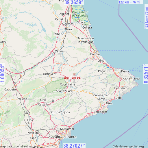
Beniarrés GPS coordinates[2]
38° 49' 12.684" North, 0° 22' 38.676" West
| Map corner | latitude | longitude |
|---|---|---|
| Upper-left | 39.3659°, | -1.08054° |
| Center: | 38.82019°, | -0.37741° |
| Lower-right: | 38.27027°, | 0.32571° |
| Map W x H: | 121.8×121.8 km | = 75.7×75.7mi |
| max Lat: | 43.74134° ⇑83.1% North |
| Beniarrés: | 38.82019° |
| min Lat: | ⇓16.9% South 27.64134° |
| min Long | Beniarrés | max Long |
| -18.00367° | -0.37741° | 4.2899° |
| W 83.5%⇐ | ⇒16.5% E |
Elevation
Elevation of Beniarrés is 395 m = 1296 ft, and this is 203 m = 666 ft below average elevation for this country.
| Max E: |
1682 m = 5518 ft | 69.3% |
| Avg. | 598 m = 1962 ft | |
| Beniarrés | 395 m = 1296 ft | |
Min E: |
0 m = 0 ft | 30.7% |
See also: Spain elevation on elevation.city.
Geographical zone
Beniarrés is located in North temperate zone (between Tropic of Cancer and the Arctic Circle). Distance of this Northern Tropic circle is 1710.5 km =1062.9 mi to South.| Distance of | km | miles | from Beniarrés |
|---|---|---|---|
| North Pole | 5690.7 | 3536 | to North |
| Arctic Circle | 3084.8 | 1916.8 | to North |
| Tropic Cancer | 1710.5 | 1062.9 | to South |
| Equator | 4316.4 | 2682.1 | to South |


Nearby cities:
15 places around Beniarrés: (largest is in red/bold)
• Alcocer de Planes
3.5 km =2.2 mi,  217°
217°
• Almudaina
7.1 km =4.4 mi,  161°
161°
• Beniatjar
4.6 km =2.9 mi,  311°
311°
• Benillup
7.4 km =4.6 mi,  181°
181°
• Benimarfull
5.1 km =3.2 mi,  193°
193°
• Bèlgida
8.4 km =5.2 mi,  293°
293°
• Carrícola
8.6 km =5.3 mi, 285°
• Castelló de Rugat
7.1 km =4.4 mi,  7°
7°
• Montichelvo
8.5 km =5.3 mi,  21°
21°
• Muro del Alcoy
6.7 km =4.2 mi,  229°
229°
• Otos
6.9 km =4.3 mi,  303°
303°
• Planes
4.9 km =3 mi,  142°
142°
• Rugat
6.7 km =4.2 mi, 12°
• Ráfol de Salem
5.5 km =3.4 mi,  339°
339°
• Terrateig
9.6 km =6 mi,  31°
31°
Sources, notices
• [Note1] Compared only with cities in Spain existing in our database
• [Src1] Map data: © OpenStreetMap contributors (CC-BY-SA)
• [Src2] Other city data from geonames.org with taken over terms of usage.
• [Src3] Geographical zone / Annual Mean Temperature by Robert A. Rohde @ Wikipedia
