Montesa geodata
Montesa (Valencia) is a seat of a third-order administrative division; located in Spain in Europe/Madrid (GMT+2) time zone. With population of 1,400 people, there are 2539 cities with bigger population in this country. Compared to other cities in Spain, 81.5% of cities are located further ↑North; 80.2% of cities are located further ←West and 75% of cities have higher elevation than Montesa. Note1


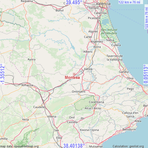
Montesa GPS coordinates[2]
38° 57' 1.08" North, 0° 39' 7.2" West
| Map corner | latitude | longitude |
|---|---|---|
| Upper-left | 39.495°, | -1.35512° |
| Center: | 38.9503°, | -0.652° |
| Lower-right: | 38.40138°, | 0.05113° |
| Map W x H: | 121.6×121.6 km | = 75.6×75.6mi |
| max Lat: | 43.74134° ⇑81.5% North |
| Montesa: | 38.9503° |
| min Lat: | ⇓18.5% South 27.64134° |
| min Long | Montesa | max Long |
| -18.00367° | -0.652° | 4.2899° |
| W 80.2%⇐ | ⇒19.8% E |
Elevation
Elevation of Montesa is 297 m = 974 ft, and this is 301 m = 988 ft below average elevation for this country.
| Max E: |
1682 m = 5518 ft | 75% |
| Avg. | 598 m = 1962 ft | |
| Montesa | 297 m = 974 ft | |
Min E: |
0 m = 0 ft | 25% |
See also: Spain elevation on elevation.city.
Geographical zone
Montesa is located in North temperate zone (between Tropic of Cancer and the Arctic Circle). Distance of this Northern Tropic circle is 1724.9 km =1071.8 mi to South.| Distance of | km | miles | from Montesa |
|---|---|---|---|
| North Pole | 5676.2 | 3527 | to North |
| Arctic Circle | 3070.3 | 1907.8 | to North |
| Tropic Cancer | 1724.9 | 1071.8 | to South |
| Equator | 4330.9 | 2691.1 | to South |


Nearby cities:
15 places around Montesa: (largest is in red/bold)
• Aielo de Malferit
9.5 km =5.9 mi,  141°
141°
• Anna
7.8 km =4.8 mi,  3°
3°
• Canals
6 km =3.7 mi,  76°
76°
• Cerdà
8.2 km =5.1 mi,  63°
63°
• Chella
10.2 km =6.3 mi,  356°
356°
• Enguera
4.4 km =2.7 mi,  317°
317°
• Estubeny
7.9 km =4.9 mi,  17°
17°
• L'Alcúdia de Crespìns
6.2 km =3.9 mi,  72°
72°
• L'Olleria
9.6 km =6 mi,  112°
112°
• Llanera de Ranes
8.3 km =5.2 mi,  53°
53°
• Novelé
9.5 km =5.9 mi, 69°
• Rotglá y Corbera
9.7 km =6 mi, 51°
• Torrella
8.3 km =5.2 mi, 62°
• Vallada
6.9 km =4.3 mi,  209°
209°
• Vallés
9.1 km =5.7 mi, 64°
Sources, notices
• [Note1] Compared only with cities in Spain existing in our database
• [Src1] Map data: © OpenStreetMap contributors (CC-BY-SA)
• [Src2] Other city data from geonames.org with taken over terms of usage.
• [Src3] Geographical zone / Annual Mean Temperature by Robert A. Rohde @ Wikipedia
