Carrícola geodata
Carrícola (Valencia) is a seat of a third-order administrative division; located in Spain in Europe/Madrid (GMT+2) time zone. With population of 79 people, there are 6152 cities with bigger population in this country. Compared to other cities in Spain, 82.8% of cities are located further ↑North; 82% of cities are located further ←West and 73.2% of cities have higher elevation than Carrícola. Note1


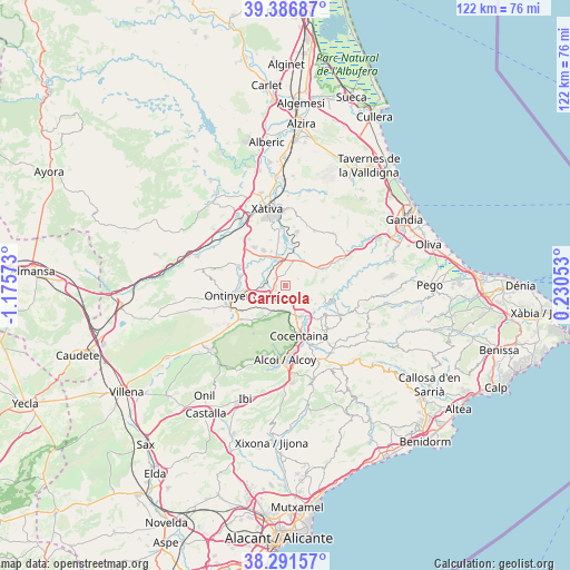
Carrícola GPS coordinates[2]
38° 50' 28.788" North, 0° 28' 21.36" West
| Map corner | latitude | longitude |
|---|---|---|
| Upper-left | 39.38687°, | -1.17573° |
| Center: | 38.84133°, | -0.4726° |
| Lower-right: | 38.29157°, | 0.23053° |
| Map W x H: | 121.8×121.8 km | = 75.7×75.7mi |
| max Lat: | 43.74134° ⇑82.8% North |
| Carrícola: | 38.84133° |
| min Lat: | ⇓17.2% South 27.64134° |
| min Long | Carrícola | max Long |
| -18.00367° | -0.4726° | 4.2899° |
| W 82%⇐ | ⇒18% E |
Elevation
Elevation of Carrícola is 328 m = 1076 ft, and this is 270 m = 886 ft below average elevation for this country.
| Max E: |
1682 m = 5518 ft | 73.2% |
| Avg. | 598 m = 1962 ft | |
| Carrícola | 328 m = 1076 ft | |
Min E: |
0 m = 0 ft | 26.8% |
See also: Spain elevation on elevation.city.
Geographical zone
Carrícola is located in North temperate zone (between Tropic of Cancer and the Arctic Circle). Distance of this Northern Tropic circle is 1712.8 km =1064.3 mi to South.| Distance of | km | miles | from Carrícola |
|---|---|---|---|
| North Pole | 5688.3 | 3534.5 | to North |
| Arctic Circle | 3082.4 | 1915.3 | to North |
| Tropic Cancer | 1712.8 | 1064.3 | to South |
| Equator | 4318.8 | 2683.6 | to South |


Nearby cities:
15 places around Carrícola: (largest is in red/bold)
• Agres
7.5 km =4.7 mi,  210°
210°
• Agullent
6.9 km =4.3 mi,  252°
252°
• Albaida
3.9 km =2.4 mi,  264°
264°
• Alcocer de Planes
8 km =5 mi,  130°
130°
• Alfarrasí
6.9 km =4.3 mi,  340°
340°
• Atzeneta d'Albaida
2.5 km =1.6 mi, 249°
• Beniatjar
4.8 km =3 mi,  81°
81°
• Benissoda
3.9 km =2.4 mi, 256°
• Bufali
4.8 km =3 mi,  307°
307°
• Bèlgida
1.1 km =0.7 mi,  28°
28°
• Montaberner
5.8 km =3.6 mi, 339°
• Muro del Alcoy
7.4 km =4.6 mi,  154°
154°
• Otos
2.9 km =1.8 mi,  59°
59°
• Palomar
2.9 km =1.8 mi,  298°
298°
• Ráfol de Salem
6.9 km =4.3 mi,  66°
66°
Sources, notices
• [Note1] Compared only with cities in Spain existing in our database
• [Src1] Map data: © OpenStreetMap contributors (CC-BY-SA)
• [Src2] Other city data from geonames.org with taken over terms of usage.
• [Src3] Geographical zone / Annual Mean Temperature by Robert A. Rohde @ Wikipedia
