Minaya geodata
Minaya (Castille-La Mancha) is a seat of a third-order administrative division; located in Spain in Europe/Madrid (GMT+2) time zone. With population of 1,701 people, there are 2335 cities with bigger population in this country. Compared to other cities in Spain, 78.8% of cities are located further ↑North; 63.1% of cities are located further ←West and 58.1% of cities have lower elevation than Minaya. Note1
Administrative division(s):
- Level 1: Castille-La Mancha
- Level 2: Provincia de Albacete
- Level 3: Minaya


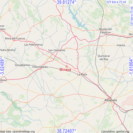
Minaya GPS coordinates[2]
39° 16' 13.872" North, 2° 19' 18.336" West
| Map corner | latitude | longitude |
|---|---|---|
| Upper-left | 39.81274°, | -3.02489° |
| Center: | 39.27052°, | -2.32176° |
| Lower-right: | 38.72407°, | -1.61864° |
| Map W x H: | 121×121 km | = 75.2×75.2mi |
| max Lat: | 43.74134° ⇑78.8% North |
| Minaya: | 39.27052° |
| min Lat: | ⇓21.2% South 27.64134° |
| min Long | Minaya | max Long |
| -18.00367° | -2.32176° | 4.2899° |
| W 63.1%⇐ | ⇒36.9% E |
Elevation
Elevation of Minaya is 730 m = 2395 ft, and this is 132 m = 433 ft above average elevation for this country.
| Max E: |
1682 m = 5518 ft | 41.9% |
| Minaya | 730 m 2395 ft | |
| Avg. | 598 m = 1962 ft | |
Min E: |
0 m = 0 ft | 58.1% |
See also: Spain elevation on elevation.city.
Geographical zone
Minaya is located in North temperate zone (between Tropic of Cancer and the Arctic Circle). Distance of this Northern Tropic circle is 1760.6 km =1094 mi to South.| Distance of | km | miles | from Minaya |
|---|---|---|---|
| North Pole | 5640.6 | 3504.9 | to North |
| Arctic Circle | 3034.7 | 1885.7 | to North |
| Tropic Cancer | 1760.6 | 1094 | to South |
| Equator | 4366.5 | 2713.2 | to South |


Nearby cities:
15 places around Minaya: (largest is in red/bold)
• Casas de Benítez
19.4 km =12.1 mi,  56°
56°
• Casas de Fernando Alonso
8.9 km =5.5 mi,  358°
358°
• Casas de Guijarro
16 km =9.9 mi, 56°
• Casas de Haro
8.2 km =5.1 mi,  31°
31°
• Casas de los Pinos
8.2 km =5.1 mi,  329°
329°
• Casasimarro
27 km =16.8 mi,  66°
66°
• El Provencio
24.8 km =15.4 mi,  298°
298°
• Fuensanta
22.3 km =13.9 mi,  100°
100°
• La Roda
15.8 km =9.8 mi,  116°
116°
• Pozoamargo
15.1 km =9.4 mi,  45°
45°
• San Clemente
17.4 km =10.8 mi, 328°
• Sisante
18.5 km =11.5 mi, 33°
• Vara de Rey
17.4 km =10.8 mi,  7°
7°
• Villagordo del Júcar
22.2 km =13.8 mi,  81°
81°
• Villarrobledo
24.1 km =15 mi,  269°
269°
Sources, notices
• [Note1] Compared only with cities in Spain existing in our database
• [Src1] Map data: © OpenStreetMap contributors (CC-BY-SA)
• [Src2] Other city data from geonames.org with taken over terms of usage.
• [Src3] Geographical zone / Annual Mean Temperature by Robert A. Rohde @ Wikipedia
