San Clemente geodata
San Clemente (Castille-La Mancha) is a seat of a third-order administrative division; located in Spain in Europe/Madrid (GMT+2) time zone. With population of 6,765 people, there are 1059 cities with bigger population in this country. Compared to other cities in Spain, 77.8% of cities are located further ↑North; 61.8% of cities are located further ←West and 57.8% of cities have lower elevation than San Clemente. Note1
Administrative division(s):
- Level 1: Castille-La Mancha
- Level 2: Provincia de Cuenca
- Level 3: San Clemente


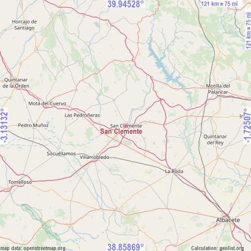
San Clemente GPS coordinates[2]
39° 24' 14.76" North, 2° 25' 41.484" West
| Map corner | latitude | longitude |
|---|---|---|
| Upper-left | 39.94528°, | -3.13132° |
| Center: | 39.4041°, | -2.42819° |
| Lower-right: | 38.85869°, | -1.72507° |
| Map W x H: | 120.8×120.8 km | = 75.1×75.1mi |
| max Lat: | 43.74134° ⇑77.8% North |
| San Clemente: | 39.4041° |
| min Lat: | ⇓22.2% South 27.64134° |
| min Long | San Clemente | max Long |
| -18.00367° | -2.42819° | 4.2899° |
| W 61.8%⇐ | ⇒38.2% E |
Elevation
Elevation of San Clemente is 728 m = 2388 ft, and this is 130 m = 427 ft above average elevation for this country.
| Max E: |
1682 m = 5518 ft | 42.2% |
| San Clemente | 728 m 2388 ft | |
| Avg. | 598 m = 1962 ft | |
Min E: |
0 m = 0 ft | 57.8% |
See also: Spain elevation on elevation.city.
Geographical zone
San Clemente is located in North temperate zone (between Tropic of Cancer and the Arctic Circle). Distance of this Northern Tropic circle is 1775.4 km =1103.2 mi to South.| Distance of | km | miles | from San Clemente |
|---|---|---|---|
| North Pole | 5625.7 | 3495.6 | to North |
| Arctic Circle | 3019.8 | 1876.4 | to North |
| Tropic Cancer | 1775.4 | 1103.2 | to South |
| Equator | 4381.3 | 2722.4 | to South |


Nearby cities:
15 places around San Clemente: (largest is in red/bold)
• Atalaya del Cañavate
19.8 km =12.3 mi,  49°
49°
• Casas de Fernando Alonso
10.7 km =6.6 mi,  123°
123°
• Casas de Guijarro
23.3 km =14.5 mi,  104°
104°
• Casas de Haro
15.5 km =9.6 mi, 120°
• Casas de los Pinos
9.3 km =5.8 mi,  147°
147°
• El Provencio
12.9 km =8 mi,  256°
256°
• La Alberca de Záncara
13.5 km =8.4 mi,  335°
335°
• Las Pedroñeras
21.7 km =13.5 mi,  283°
283°
• Minaya
17.4 km =10.8 mi, 148°
• Pinarejo
23.6 km =14.7 mi,  0°
0°
• Pozoamargo
20.4 km =12.7 mi, 102°
• Santa María del Campo Rus
17.3 km =10.7 mi, 1°
• Sisante
19.5 km =12.1 mi,  88°
88°
• Vara de Rey
11.8 km =7.3 mi,  78°
78°
• Villarrobledo
21.1 km =13.1 mi,  224°
224°
Sources, notices
• [Note1] Compared only with cities in Spain existing in our database
• [Src1] Map data: © OpenStreetMap contributors (CC-BY-SA)
• [Src2] Other city data from geonames.org with taken over terms of usage.
• [Src3] Geographical zone / Annual Mean Temperature by Robert A. Rohde @ Wikipedia
