La Roda geodata
La Roda (Castille-La Mancha) is a populated place; located in Spain in Europe/Madrid (GMT+2) time zone. With population of 16,060 people, there are 586 cities with bigger population in this country. Compared to other cities in Spain, 79.4% of cities are located further ↑North; 65.4% of cities are located further ←West and 55.6% of cities have lower elevation than La Roda. Note1
Administrative division(s):
- Level 1: Castille-La Mancha
- Level 2: Provincia de Albacete
- Level 3: Roda, La


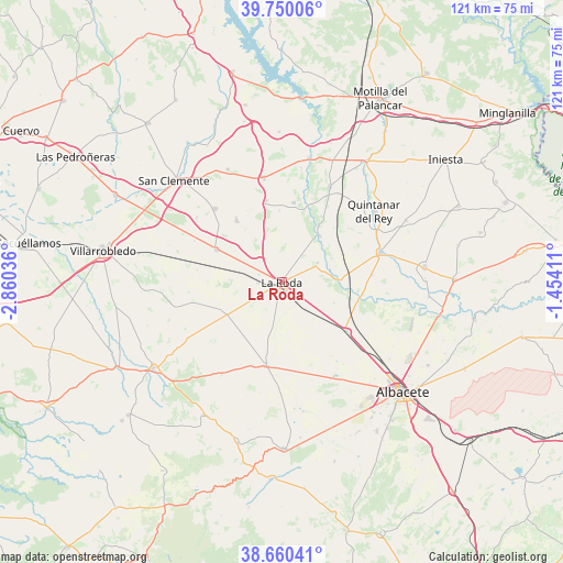
La Roda GPS coordinates[2]
39° 12' 26.46" North, 2° 9' 26.028" West
| Map corner | latitude | longitude |
|---|---|---|
| Upper-left | 39.75006°, | -2.86036° |
| Center: | 39.20735°, | -2.15723° |
| Lower-right: | 38.66041°, | -1.45411° |
| Map W x H: | 121.2×121.2 km | = 75.3×75.3mi |
| max Lat: | 43.74134° ⇑79.4% North |
| La Roda: | 39.20735° |
| min Lat: | ⇓20.6% South 27.64134° |
| min Long | La Roda | max Long |
| -18.00367° | -2.15723° | 4.2899° |
| W 65.4%⇐ | ⇒34.6% E |
Elevation
Elevation of La Roda is 713 m = 2339 ft, and this is 115 m = 377 ft above average elevation for this country.
| Max E: |
1682 m = 5518 ft | 44.4% |
| La Roda | 713 m 2339 ft | |
| Avg. | 598 m = 1962 ft | |
Min E: |
0 m = 0 ft | 55.6% |
See also: Spain elevation on elevation.city.
Geographical zone
La Roda is located in North temperate zone (between Tropic of Cancer and the Arctic Circle). Distance of this Northern Tropic circle is 1753.5 km =1089.6 mi to South.| Distance of | km | miles | from La Roda |
|---|---|---|---|
| North Pole | 5647.6 | 3509.3 | to North |
| Arctic Circle | 3041.7 | 1890 | to North |
| Tropic Cancer | 1753.5 | 1089.6 | to South |
| Equator | 4359.4 | 2708.8 | to South |


Nearby cities:
15 places around La Roda: (largest is in red/bold)
• Barrax
18.3 km =11.4 mi,  192°
192°
• Casas de Benítez
17.8 km =11.1 mi,  6°
6°
• Casas de Fernando Alonso
21.4 km =13.3 mi,  317°
317°
• Casas de Guijarro
15.9 km =9.9 mi,  357°
357°
• Casas de Haro
17.2 km =10.7 mi, 324°
• Casas de los Pinos
23.1 km =14.4 mi,  307°
307°
• Casasimarro
20.7 km =12.9 mi,  31°
31°
• Fuensanta
8.3 km =5.2 mi,  69°
69°
• La Gineta
17.3 km =10.7 mi,  126°
126°
• Minaya
15.8 km =9.8 mi,  296°
296°
• Montalvos
12.9 km =8 mi,  110°
110°
• Pozoamargo
17.9 km =11.1 mi,  349°
349°
• Sisante
22.7 km =14.1 mi, 350°
• Tarazona de la Mancha
21.3 km =13.2 mi,  77°
77°
• Villagordo del Júcar
12.9 km =8 mi,  37°
37°
Sources, notices
• [Note1] Compared only with cities in Spain existing in our database
• [Src1] Map data: © OpenStreetMap contributors (CC-BY-SA)
• [Src2] Other city data from geonames.org with taken over terms of usage.
• [Src3] Geographical zone / Annual Mean Temperature by Robert A. Rohde @ Wikipedia
