Hontecillas geodata
Hontecillas (Castille-La Mancha) is a seat of a third-order administrative division; located in Spain in Europe/Madrid (GMT+2) time zone. With population of 98 people, there are 5963 cities with bigger population in this country. Compared to other cities in Spain, 74.5% of cities are located further ↑North; 64.9% of cities are located further ←West and 73% of cities have lower elevation than Hontecillas. Note1
Administrative division(s):
- Level 1: Castille-La Mancha
- Level 2: Provincia de Cuenca
- Level 3: Hontecillas


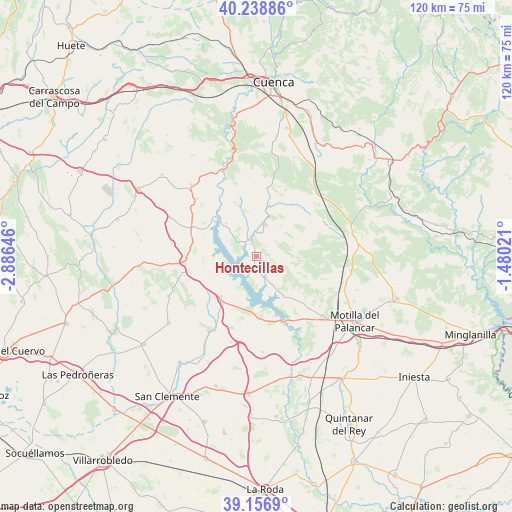
Hontecillas GPS coordinates[2]
39° 42' 0" North, 2° 10' 59.988" West
| Map corner | latitude | longitude |
|---|---|---|
| Upper-left | 40.23886°, | -2.88646° |
| Center: | 39.7°, | -2.18333° |
| Lower-right: | 39.1569°, | -1.48021° |
| Map W x H: | 120.3×120.3 km | = 74.8×74.8mi |
| max Lat: | 43.74134° ⇑74.5% North |
| Hontecillas: | 39.7° |
| min Lat: | ⇓25.5% South 27.64134° |
| min Long | Hontecillas | max Long |
| -18.00367° | -2.18333° | 4.2899° |
| W 64.9%⇐ | ⇒35.1% E |
Elevation
Elevation of Hontecillas is 835 m = 2740 ft, and this is 237 m = 778 ft above average elevation for this country.
| Max E: |
1682 m = 5518 ft | 27% |
| Hontecillas | 835 m 2740 ft | |
| Avg. | 598 m = 1962 ft | |
Min E: |
0 m = 0 ft | 73% |
See also: Spain elevation on elevation.city.
Geographical zone
Hontecillas is located in North temperate zone (between Tropic of Cancer and the Arctic Circle). Distance of this Northern Tropic circle is 1808.3 km =1123.6 mi to South.| Distance of | km | miles | from Hontecillas |
|---|---|---|---|
| North Pole | 5592.8 | 3475.2 | to North |
| Arctic Circle | 2986.9 | 1856 | to North |
| Tropic Cancer | 1808.3 | 1123.6 | to South |
| Equator | 4414.2 | 2742.9 | to South |


Nearby cities:
15 places around Hontecillas: (largest is in red/bold)
• Albaladejo del Cuende
12.5 km =7.8 mi,  341°
341°
• Barchín del Hoyo
10.6 km =6.6 mi,  110°
110°
• Buenache de Alarcón
5.7 km =3.5 mi,  165°
165°
• Castillo de Garcimuñoz
17.5 km =10.9 mi,  254°
254°
• Chumillas
14.8 km =9.2 mi,  59°
59°
• Honrubia
12.7 km =7.9 mi,  220°
220°
• La Almarcha
16.9 km =10.5 mi,  264°
264°
• Olivares de Júcar
16.2 km =10.1 mi,  294°
294°
• Olmeda del Rey
14 km =8.7 mi,  37°
37°
• Olmedilla de Alarcón
11.7 km =7.3 mi,  142°
142°
• Piqueras del Castillo
10.1 km =6.3 mi,  79°
79°
• Torrubia del Castillo
11.9 km =7.4 mi, 247°
• Valverde de Júcar
3.9 km =2.4 mi,  302°
302°
• Valverdejo
17 km =10.6 mi,  123°
123°
• Villaverde y Pasaconsol
10.6 km =6.6 mi,  318°
318°
Sources, notices
• [Note1] Compared only with cities in Spain existing in our database
• [Src1] Map data: © OpenStreetMap contributors (CC-BY-SA)
• [Src2] Other city data from geonames.org with taken over terms of usage.
• [Src3] Geographical zone / Annual Mean Temperature by Robert A. Rohde @ Wikipedia
