Honrubia geodata
Honrubia (Castille-La Mancha) is a seat of a third-order administrative division; located in Spain in Europe/Madrid (GMT+2) time zone. With population of 1,651 people, there are 2372 cities with bigger population in this country. Compared to other cities in Spain, 75.6% of cities are located further ↑North; 63.7% of cities are located further ←West and 70.4% of cities have lower elevation than Honrubia. Note1
Administrative division(s):
- Level 1: Castille-La Mancha
- Level 2: Provincia de Cuenca
- Level 3: Honrubia


Honrubia GPS coordinates[2]
39° 36' 48.888" North, 2° 16' 50.772" West
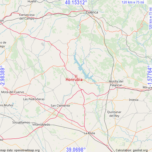
| Map corner | latitude | longitude |
|---|---|---|
| Upper-left | 40.15312°, | -2.98389° |
| Center: | 39.61358°, | -2.28077° |
| Lower-right: | 39.0698°, | -1.57764° |
| Map W x H: | 120.5×120.5 km | = 74.9×74.9mi |
| max Lat: | 43.74134° ⇑75.6% North |
| Honrubia: | 39.61358° |
| min Lat: | ⇓24.4% South 27.64134° |
| min Long | Honrubia | max Long |
| -18.00367° | -2.28077° | 4.2899° |
| W 63.7%⇐ | ⇒36.3% E |
Elevation
Elevation of Honrubia is 817 m = 2680 ft, and this is 219 m = 719 ft above average elevation for this country.
| Max E: |
1682 m = 5518 ft | 29.6% |
| Honrubia | 817 m 2680 ft | |
| Avg. | 598 m = 1962 ft | |
Min E: |
0 m = 0 ft | 70.4% |
See also: Spain elevation on elevation.city.
Geographical zone
Honrubia is located in North temperate zone (between Tropic of Cancer and the Arctic Circle). Distance of this Northern Tropic circle is 1798.7 km =1117.7 mi to South.| Distance of | km | miles | from Honrubia |
|---|---|---|---|
| North Pole | 5602.4 | 3481.2 | to North |
| Arctic Circle | 2996.6 | 1862 | to North |
| Tropic Cancer | 1798.7 | 1117.7 | to South |
| Equator | 4404.6 | 2736.9 | to South |


Nearby cities:
15 places around Honrubia: (largest is in red/bold)
• Alarcón
18.3 km =11.4 mi,  112°
112°
• Atalaya del Cañavate
10.8 km =6.7 mi,  166°
166°
• Barchín del Hoyo
19.3 km =12 mi,  72°
72°
• Buenache de Alarcón
10.6 km =6.6 mi, 67°
• Castillo de Garcimuñoz
9.9 km =6.2 mi,  300°
300°
• Hontecillas
12.7 km =7.9 mi,  40°
40°
• La Almarcha
11.7 km =7.3 mi,  313°
313°
• Olivares de Júcar
17.6 km =10.9 mi,  338°
338°
• Olmedilla de Alarcón
15.5 km =9.6 mi,  88°
88°
• Pinarejo
12.4 km =7.7 mi,  271°
271°
• Santa María del Campo Rus
13.6 km =8.5 mi,  243°
243°
• Torrubia del Castillo
5.7 km =3.5 mi,  332°
332°
• Tébar
16 km =9.9 mi,  142°
142°
• Valverde de Júcar
12.7 km =7.9 mi,  23°
23°
• Villaverde y Pasaconsol
17.6 km =10.9 mi,  4°
4°
Sources, notices
• [Note1] Compared only with cities in Spain existing in our database
• [Src1] Map data: © OpenStreetMap contributors (CC-BY-SA)
• [Src2] Other city data from geonames.org with taken over terms of usage.
• [Src3] Geographical zone / Annual Mean Temperature by Robert A. Rohde @ Wikipedia
