Montanejos geodata
Montanejos (Valencia) is a seat of a third-order administrative division; located in Spain in Europe/Madrid (GMT+2) time zone. With population of 499 people, there are 3891 cities with bigger population in this country. Compared to other cities in Spain, 69.2% of cities are located further ↑North; 81.5% of cities are located further ←West and 64.9% of cities have higher elevation than Montanejos. Note1


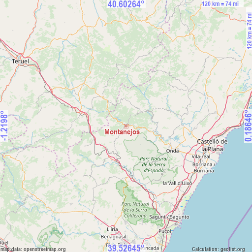
Montanejos GPS coordinates[2]
40° 4' 0.012" North, 0° 31' 0.012" West
| Map corner | latitude | longitude |
|---|---|---|
| Upper-left | 40.60264°, | -1.2198° |
| Center: | 40.06667°, | -0.51667° |
| Lower-right: | 39.52645°, | 0.18646° |
| Map W x H: | 119.7×119.7 km | = 74.4×74.4mi |
| max Lat: | 43.74134° ⇑69.2% North |
| Montanejos: | 40.06667° |
| min Lat: | ⇓30.8% South 27.64134° |
| min Long | Montanejos | max Long |
| -18.00367° | -0.51667° | 4.2899° |
| W 81.5%⇐ | ⇒18.5% E |
Elevation
Elevation of Montanejos is 461 m = 1512 ft, and this is 137 m = 449 ft below average elevation for this country.
| Max E: |
1682 m = 5518 ft | 64.9% |
| Avg. | 598 m = 1962 ft | |
| Montanejos | 461 m = 1512 ft | |
Min E: |
0 m = 0 ft | 35.1% |
See also: Spain elevation on elevation.city.
Geographical zone
Montanejos is located in North temperate zone (between Tropic of Cancer and the Arctic Circle). Distance of this Northern Tropic circle is 1849.1 km =1149 mi to South.| Distance of | km | miles | from Montanejos |
|---|---|---|---|
| North Pole | 5552.1 | 3449.9 | to North |
| Arctic Circle | 2946.2 | 1830.7 | to North |
| Tropic Cancer | 1849.1 | 1149 | to South |
| Equator | 4455 | 2768.2 | to South |


Nearby cities:
15 places around Montanejos: (largest is in red/bold)
• Arañuel
2.8 km =1.7 mi,  90°
90°
• Cirat
6 km =3.7 mi,  108°
108°
• Fuente la Reina
7.1 km =4.4 mi,  270°
270°
• Fuentes de Ayódar
9.3 km =5.8 mi, 113°
• Higueras
9.4 km =5.8 mi,  171°
171°
• Ludiente
12.9 km =8 mi,  81°
81°
• Montán
4.7 km =2.9 mi,  217°
217°
• Olba
11.3 km =7 mi,  311°
311°
• Pavías
11.5 km =7.1 mi, 165°
• Pina de Montalgrao
12.6 km =7.8 mi,  243°
243°
• Puebla de Arenoso
6.8 km =4.2 mi,  303°
303°
• Torralba del Pinar
11.7 km =7.3 mi,  142°
142°
• Torrechiva
10.1 km =6.3 mi,  100°
100°
• Villanueva de Viver
11.5 km =7.1 mi,  260°
260°
• Zucaina
10.2 km =6.3 mi,  56°
56°
Sources, notices
• [Note1] Compared only with cities in Spain existing in our database
• [Src1] Map data: © OpenStreetMap contributors (CC-BY-SA)
• [Src2] Other city data from geonames.org with taken over terms of usage.
• [Src3] Geographical zone / Annual Mean Temperature by Robert A. Rohde @ Wikipedia
