Cenizate geodata
Cenizate (Castille-La Mancha) is a seat of a third-order administrative division; located in Spain in Europe/Madrid (GMT+2) time zone. With population of 1,204 people, there are 2721 cities with bigger population in this country. Compared to other cities in Spain, 78.6% of cities are located further ↑North; 71.3% of cities are located further ←West and 53.4% of cities have lower elevation than Cenizate. Note1
Administrative division(s):
- Level 1: Castille-La Mancha
- Level 2: Provincia de Albacete
- Level 3: Cenizate


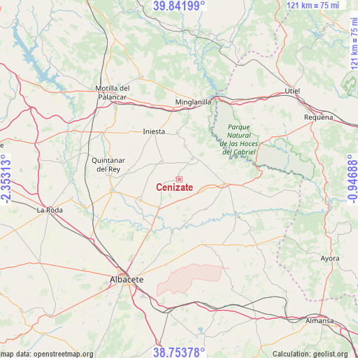
Cenizate GPS coordinates[2]
39° 18' 0" North, 1° 39' 0" West
| Map corner | latitude | longitude |
|---|---|---|
| Upper-left | 39.84199°, | -2.35313° |
| Center: | 39.3°, | -1.65° |
| Lower-right: | 38.75378°, | -0.94688° |
| Map W x H: | 121×121 km | = 75.2×75.2mi |
| max Lat: | 43.74134° ⇑78.6% North |
| Cenizate: | 39.3° |
| min Lat: | ⇓21.4% South 27.64134° |
| min Long | Cenizate | max Long |
| -18.00367° | -1.65° | 4.2899° |
| W 71.3%⇐ | ⇒28.7% E |
Elevation
Elevation of Cenizate is 695 m = 2280 ft, and this is 97 m = 318 ft above average elevation for this country.
| Max E: |
1682 m = 5518 ft | 46.6% |
| Cenizate | 695 m 2280 ft | |
| Avg. | 598 m = 1962 ft | |
Min E: |
0 m = 0 ft | 53.4% |
See also: Spain elevation on elevation.city.
Geographical zone
Cenizate is located in North temperate zone (between Tropic of Cancer and the Arctic Circle). Distance of this Northern Tropic circle is 1763.8 km =1096 mi to South.| Distance of | km | miles | from Cenizate |
|---|---|---|---|
| North Pole | 5637.3 | 3502.9 | to North |
| Arctic Circle | 3031.4 | 1883.6 | to North |
| Tropic Cancer | 1763.8 | 1096 | to South |
| Equator | 4369.8 | 2715.3 | to South |


Nearby cities:
15 places around Cenizate: (largest is in red/bold)
• Abengibre
13.7 km =8.5 mi,  132°
132°
• Casas Ibáñez
15.9 km =9.9 mi,  96°
96°
• El Herrumblar
11.5 km =7.1 mi,  14°
14°
• Fuentealbilla
9.4 km =5.8 mi,  113°
113°
• Golosalvo
7.6 km =4.7 mi,  169°
169°
• Iniesta
17.1 km =10.6 mi,  329°
329°
• Ledaña
8.6 km =5.3 mi, 329°
• Madrigueras
14.9 km =9.3 mi,  240°
240°
• Mahora
11.7 km =7.3 mi,  217°
217°
• Motilleja
17.3 km =10.7 mi, 221°
• Navas de Jorquera
6 km =3.7 mi,  252°
252°
• Valdeganga
18.5 km =11.5 mi,  187°
187°
• Villagarcía del Llano
15.9 km =9.9 mi,  276°
276°
• Villamalea
9.4 km =5.8 mi,  37°
37°
• Villarta
16.7 km =10.4 mi,  0°
0°
Sources, notices
• [Note1] Compared only with cities in Spain existing in our database
• [Src1] Map data: © OpenStreetMap contributors (CC-BY-SA)
• [Src2] Other city data from geonames.org with taken over terms of usage.
• [Src3] Geographical zone / Annual Mean Temperature by Robert A. Rohde @ Wikipedia
