Valdeganga geodata
Valdeganga (Castille-La Mancha) is a seat of a third-order administrative division; located in Spain in Europe/Madrid (GMT+2) time zone. With population of 1,871 people, there are 2246 cities with bigger population in this country. Compared to other cities in Spain, 79.9% of cities are located further ↑North; 71% of cities are located further ←West and 50.8% of cities have lower elevation than Valdeganga. Note1
Administrative division(s):
- Level 1: Castille-La Mancha
- Level 2: Provincia de Albacete
- Level 3: Valdeganga


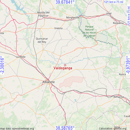
Valdeganga GPS coordinates[2]
39° 8' 6.504" North, 1° 40' 37.308" West
| Map corner | latitude | longitude |
|---|---|---|
| Upper-left | 39.67841°, | -2.38016° |
| Center: | 39.13514°, | -1.67703° |
| Lower-right: | 38.58765°, | -0.97391° |
| Map W x H: | 121.3×121.3 km | = 75.4×75.4mi |
| max Lat: | 43.74134° ⇑79.9% North |
| Valdeganga: | 39.13514° |
| min Lat: | ⇓20.1% South 27.64134° |
| min Long | Valdeganga | max Long |
| -18.00367° | -1.67703° | 4.2899° |
| W 71%⇐ | ⇒29% E |
Elevation
Elevation of Valdeganga is 667 m = 2188 ft, and this is 69 m = 226 ft above average elevation for this country.
| Max E: |
1682 m = 5518 ft | 49.2% |
| Valdeganga | 667 m 2188 ft | |
| Avg. | 598 m = 1962 ft | |
Min E: |
0 m = 0 ft | 50.8% |
See also: Spain elevation on elevation.city.
Geographical zone
Valdeganga is located in North temperate zone (between Tropic of Cancer and the Arctic Circle). Distance of this Northern Tropic circle is 1745.5 km =1084.6 mi to South.| Distance of | km | miles | from Valdeganga |
|---|---|---|---|
| North Pole | 5655.6 | 3514.2 | to North |
| Arctic Circle | 3049.8 | 1895.1 | to North |
| Tropic Cancer | 1745.5 | 1084.6 | to South |
| Equator | 4351.4 | 2703.8 | to South |


Nearby cities:
15 places around Valdeganga: (largest is in red/bold)
• Abengibre
15.3 km =9.5 mi,  53°
53°
• Albacete
22 km =13.7 mi,  224°
224°
• Alcalá del Júcar
22.2 km =13.8 mi,  73°
73°
• Casas de Juan Núñez
10.9 km =6.8 mi,  109°
109°
• Cenizate
18.5 km =11.5 mi,  7°
7°
• Fuentealbilla
18.3 km =11.4 mi,  36°
36°
• Golosalvo
11.5 km =7.1 mi,  19°
19°
• Hoya-Gonzalo
22.3 km =13.9 mi,  152°
152°
• Jorquera
14.3 km =8.9 mi,  75°
75°
• Madrigueras
15.2 km =9.4 mi,  315°
315°
• Mahora
10.3 km =6.4 mi,  331°
331°
• Motilleja
10.6 km =6.6 mi,  300°
300°
• Navas de Jorquera
16.8 km =10.4 mi,  348°
348°
• Pozo Lorente
16.1 km =10 mi, 114°
• Villavaliente
19 km =11.8 mi,  92°
92°
Sources, notices
• [Note1] Compared only with cities in Spain existing in our database
• [Src1] Map data: © OpenStreetMap contributors (CC-BY-SA)
• [Src2] Other city data from geonames.org with taken over terms of usage.
• [Src3] Geographical zone / Annual Mean Temperature by Robert A. Rohde @ Wikipedia
