Abengibre geodata
Abengibre (Castille-La Mancha) is a seat of a third-order administrative division; located in Spain in Europe/Madrid (GMT+2) time zone. With population of 991 people, there are 2964 cities with bigger population in this country. Compared to other cities in Spain, 79.3% of cities are located further ↑North; 72.5% of cities are located further ←West and 50.6% of cities have higher elevation than Abengibre. Note1
Administrative division(s):
- Level 1: Castille-La Mancha
- Level 2: Provincia de Albacete
- Level 3: Abengibre


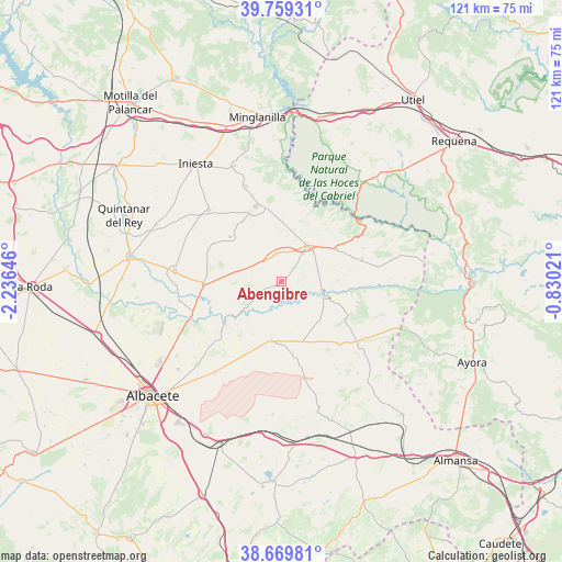
Abengibre GPS coordinates[2]
39° 13' 0.012" North, 1° 31' 59.988" West
| Map corner | latitude | longitude |
|---|---|---|
| Upper-left | 39.75931°, | -2.23646° |
| Center: | 39.21667°, | -1.53333° |
| Lower-right: | 38.66981°, | -0.83021° |
| Map W x H: | 121.1×121.1 km | = 75.2×75.2mi |
| max Lat: | 43.74134° ⇑79.3% North |
| Abengibre: | 39.21667° |
| min Lat: | ⇓20.7% South 27.64134° |
| min Long | Abengibre | max Long |
| -18.00367° | -1.53333° | 4.2899° |
| W 72.5%⇐ | ⇒27.5% E |
Elevation
Elevation of Abengibre is 651 m = 2136 ft, and this is 53 m = 174 ft above average elevation for this country.
| Max E: |
1682 m = 5518 ft | 50.6% |
| Abengibre | 651 m 2136 ft | |
| Avg. | 598 m = 1962 ft | |
Min E: |
0 m = 0 ft | 49.4% |
See also: Spain elevation on elevation.city.
Geographical zone
Abengibre is located in North temperate zone (between Tropic of Cancer and the Arctic Circle). Distance of this Northern Tropic circle is 1754.6 km =1090.3 mi to South.| Distance of | km | miles | from Abengibre |
|---|---|---|---|
| North Pole | 5646.6 | 3508.6 | to North |
| Arctic Circle | 3040.7 | 1889.4 | to North |
| Tropic Cancer | 1754.6 | 1090.3 | to South |
| Equator | 4360.5 | 2709.5 | to South |


Nearby cities:
15 places around Abengibre: (largest is in red/bold)
• Alborea
14.9 km =9.3 mi,  60°
60°
• Alcalá del Júcar
9.3 km =5.8 mi,  106°
106°
• Casas Ibáñez
9.4 km =5.8 mi,  37°
37°
• Casas de Juan Núñez
12.9 km =8 mi,  189°
189°
• Casas de Ves
17.6 km =10.9 mi,  77°
77°
• Cenizate
13.7 km =8.5 mi,  312°
312°
• Fuentealbilla
5.7 km =3.5 mi,  345°
345°
• Golosalvo
8.8 km =5.5 mi,  282°
282°
• Jorquera
5.7 km =3.5 mi,  165°
165°
• Mahora
17.2 km =10.7 mi,  270°
270°
• Navas de Jorquera
17.4 km =10.8 mi,  295°
295°
• Pozo Lorente
15.8 km =9.8 mi, 171°
• Valdeganga
15.3 km =9.5 mi,  233°
233°
• Villamalea
17.2 km =10.7 mi, 345°
• Villavaliente
12 km =7.5 mi,  146°
146°
Sources, notices
• [Note1] Compared only with cities in Spain existing in our database
• [Src1] Map data: © OpenStreetMap contributors (CC-BY-SA)
• [Src2] Other city data from geonames.org with taken over terms of usage.
• [Src3] Geographical zone / Annual Mean Temperature by Robert A. Rohde @ Wikipedia
