Agres geodata
Agres (Valencia) is a seat of a third-order administrative division; located in Spain in Europe/Madrid (GMT+2) time zone. With population of 709 people, there are 3390 cities with bigger population in this country. Compared to other cities in Spain, 83.4% of cities are located further ↑North; 81.5% of cities are located further ←West and 51.2% of cities have lower elevation than Agres. Note1


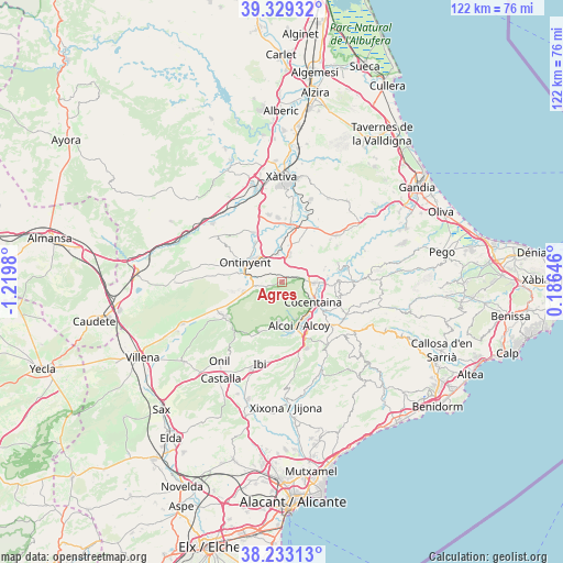
Agres GPS coordinates[2]
38° 46' 59.988" North, 0° 31' 0.012" West
| Map corner | latitude | longitude |
|---|---|---|
| Upper-left | 39.32932°, | -1.2198° |
| Center: | 38.78333°, | -0.51667° |
| Lower-right: | 38.23313°, | 0.18646° |
| Map W x H: | 121.9×121.9 km | = 75.7×75.7mi |
| max Lat: | 43.74134° ⇑83.4% North |
| Agres: | 38.78333° |
| min Lat: | ⇓16.6% South 27.64134° |
| min Long | Agres | max Long |
| -18.00367° | -0.51667° | 4.2899° |
| W 81.5%⇐ | ⇒18.5% E |
Elevation
Elevation of Agres is 671 m = 2201 ft, and this is 73 m = 240 ft above average elevation for this country.
| Max E: |
1682 m = 5518 ft | 48.8% |
| Agres | 671 m 2201 ft | |
| Avg. | 598 m = 1962 ft | |
Min E: |
0 m = 0 ft | 51.2% |
See also: Spain elevation on elevation.city.
Geographical zone
Agres is located in North temperate zone (between Tropic of Cancer and the Arctic Circle). Distance of this Northern Tropic circle is 1706.4 km =1060.3 mi to South.| Distance of | km | miles | from Agres |
|---|---|---|---|
| North Pole | 5694.8 | 3538.6 | to North |
| Arctic Circle | 3088.9 | 1919.4 | to North |
| Tropic Cancer | 1706.4 | 1060.3 | to South |
| Equator | 4312.3 | 2679.5 | to South |


Nearby cities:
15 places around Agres: (largest is in red/bold)
• Agullent
5.2 km =3.2 mi,  327°
327°
• Albaida
6.1 km =3.8 mi,  359°
359°
• Alcocer de Planes
10 km =6.2 mi,  82°
82°
• Alcoy
9.4 km =5.8 mi,  157°
157°
• Alfafara
3.5 km =2.2 mi,  251°
251°
• Atzeneta d'Albaida
5.7 km =3.5 mi,  14°
14°
• Benissoda
5.6 km =3.5 mi,  0°
0°
• Bocairent
8.9 km =5.5 mi,  257°
257°
• Bufali
9.4 km =5.8 mi, 0°
• Bèlgida
8.6 km =5.3 mi,  30°
30°
• Carrícola
7.5 km =4.7 mi, 30°
• Cocentaina
8.2 km =5.1 mi,  126°
126°
• Muro del Alcoy
7 km =4.3 mi,  91°
91°
• Ontinyent
8.9 km =5.5 mi,  298°
298°
• Palomar
7.9 km =4.9 mi, 8°
Sources, notices
• [Note1] Compared only with cities in Spain existing in our database
• [Src1] Map data: © OpenStreetMap contributors (CC-BY-SA)
• [Src2] Other city data from geonames.org with taken over terms of usage.
• [Src3] Geographical zone / Annual Mean Temperature by Robert A. Rohde @ Wikipedia
