Cañaveral de León geodata
Cañaveral de León (Andalusia) is a seat of a third-order administrative division; located in Spain in Europe/Madrid (GMT+2) time zone. In our database, there are 6762 cities with bigger population. Compared to other cities in Spain, 88.5% of cities are located further ↑North; 91.3% of cities are located further →East and 59.9% of cities have higher elevation than Cañaveral de León. Note1
Administrative division(s):
- Level 1: Andalusia
- Level 2: Provincia de Huelva
- Level 3: Cañaveral de León


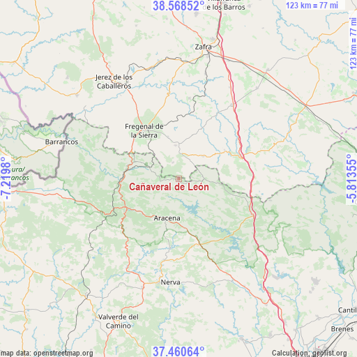
Cañaveral de León GPS coordinates[2]
38° 1' 0.012" North, 6° 31' 0.012" West
| Map corner | latitude | longitude |
|---|---|---|
| Upper-left | 38.56852°, | -7.2198° |
| Center: | 38.01667°, | -6.51667° |
| Lower-right: | 37.46064°, | -5.81355° |
| Map W x H: | 123.2×123.2 km | = 76.6×76.6mi |
| max Lat: | 43.74134° ⇑88.5% North |
| Cañaveral de León: | 38.01667° |
| min Lat: | ⇓11.5% South 27.64134° |
| min Long | Cañaveral de L | max Long |
| -18.00367° | -6.51667° | 4.2899° |
| W 8.7%⇐ | ⇒91.3% E |
Elevation
Elevation of Cañaveral de León is 528 m = 1732 ft, and this is 70 m = 230 ft below average elevation for this country.
| Max E: |
1682 m = 5518 ft | 59.9% |
| Avg. | 598 m = 1962 ft | |
| Cañaveral de León | 528 m = 1732 ft | |
Min E: |
0 m = 0 ft | 40.1% |
See also: Spain elevation on elevation.city.
Geographical zone
Cañaveral de León is located in North temperate zone (between Tropic of Cancer and the Arctic Circle). Distance of this Northern Tropic circle is 1621.1 km =1007.3 mi to South.| Distance of | km | miles | from Cañaveral de León |
|---|---|---|---|
| North Pole | 5780 | 3591.5 | to North |
| Arctic Circle | 3174.1 | 1972.3 | to North |
| Tropic Cancer | 1621.1 | 1007.3 | to South |
| Equator | 4227.1 | 2626.6 | to South |


Nearby cities:
15 places around Cañaveral de León: (largest is in red/bold)
• Aracena
14.2 km =8.8 mi,  195°
195°
• Arroyomolinos de León
8.8 km =5.5 mi,  90°
90°
• Bodonal de la Sierra
15 km =9.3 mi,  345°
345°
• Cabeza la Vaca
11.5 km =7.1 mi,  49°
49°
• Cala
18.4 km =11.4 mi,  107°
107°
• Calera de León
18.5 km =11.5 mi,  60°
60°
• Corteconcepción
13.1 km =8.1 mi,  173°
173°
• Cortelazor
13 km =8.1 mi,  226°
226°
• Cumbres Mayores
12.4 km =7.7 mi,  294°
294°
• Fuenteheridos
17.7 km =11 mi, 225°
• Fuentes de León
6.1 km =3.8 mi,  341°
341°
• Hinojales
6.1 km =3.8 mi,  252°
252°
• Linares de la Sierra
17.9 km =11.1 mi,  211°
211°
• Segura de León
11.1 km =6.9 mi,  0°
0°
• Valdelarco
16.3 km =10.1 mi,  242°
242°
Sources, notices
• [Note1] Compared only with cities in Spain existing in our database
• [Src1] Map data: © OpenStreetMap contributors (CC-BY-SA)
• [Src2] Other city data from geonames.org with taken over terms of usage.
• [Src3] Geographical zone / Annual Mean Temperature by Robert A. Rohde @ Wikipedia
