Aracena geodata
Aracena (Andalusia) is a seat of a third-order administrative division; located in Spain in Europe/Madrid (GMT+2) time zone. With population of 7,351 people, there are 996 cities with bigger population in this country. Compared to other cities in Spain, 89.1% of cities are located further ↑North; 91.7% of cities are located further →East and 51.5% of cities have lower elevation than Aracena. Note1


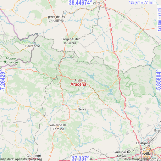
Aracena GPS coordinates[2]
37° 53' 38.256" North, 6° 33' 40.176" West
| Map corner | latitude | longitude |
|---|---|---|
| Upper-left | 38.44674°, | -7.26429° |
| Center: | 37.89396°, | -6.56116° |
| Lower-right: | 37.337°, | -5.85804° |
| Map W x H: | 123.4×123.4 km | = 76.7×76.7mi |
| max Lat: | 43.74134° ⇑89.1% North |
| Aracena: | 37.89396° |
| min Lat: | ⇓10.9% South 27.64134° |
| min Long | Aracena | max Long |
| -18.00367° | -6.56116° | 4.2899° |
| W 8.3%⇐ | ⇒91.7% E |
Elevation
Elevation of Aracena is 675 m = 2215 ft, and this is 77 m = 253 ft above average elevation for this country.
| Max E: |
1682 m = 5518 ft | 48.5% |
| Aracena | 675 m 2215 ft | |
| Avg. | 598 m = 1962 ft | |
Min E: |
0 m = 0 ft | 51.5% |
See also: Spain elevation on elevation.city.
Geographical zone
Aracena is located in North temperate zone (between Tropic of Cancer and the Arctic Circle). Distance of this Northern Tropic circle is 1607.5 km =998.9 mi to South.| Distance of | km | miles | from Aracena |
|---|---|---|---|
| North Pole | 5793.6 | 3600 | to North |
| Arctic Circle | 3187.8 | 1980.8 | to North |
| Tropic Cancer | 1607.5 | 998.9 | to South |
| Equator | 4213.4 | 2618.1 | to South |


Nearby cities:
15 places around Aracena: (largest is in red/bold)
• Alájar
9.4 km =5.8 mi,  256°
256°
• Arroyomolinos de León
18.6 km =11.6 mi,  42°
42°
• Campofrío
14.2 km =8.8 mi,  184°
184°
• Cañaveral de León
14.2 km =8.8 mi,  15°
15°
• Corteconcepción
5.4 km =3.4 mi,  82°
82°
• Cortelazor
7.3 km =4.5 mi,  310°
310°
• Fuenteheridos
8.9 km =5.5 mi,  278°
278°
• Fuentes de León
19.5 km =12.1 mi,  5°
5°
• Galaroza
13.4 km =8.3 mi,  286°
286°
• Higuera de la Sierra
11.9 km =7.4 mi,  124°
124°
• Hinojales
11.9 km =7.4 mi,  350°
350°
• Jabugo
15 km =9.3 mi, 279°
• Linares de la Sierra
5.7 km =3.5 mi,  253°
253°
• Santa Ana la Real
14.7 km =9.1 mi, 256°
• Valdelarco
12.2 km =7.6 mi,  299°
299°
Sources, notices
• [Note1] Compared only with cities in Spain existing in our database
• [Src1] Map data: © OpenStreetMap contributors (CC-BY-SA)
• [Src2] Other city data from geonames.org with taken over terms of usage.
• [Src3] Geographical zone / Annual Mean Temperature by Robert A. Rohde @ Wikipedia
