Garvín geodata
Garvín (Extremadura) is a seat of a third-order administrative division; located in Spain in Europe/Madrid (GMT+2) time zone. With population of 104 people, there are 5880 cities with bigger population in this country. Compared to other cities in Spain, 74% of cities are located further ↑North; 76.8% of cities are located further →East and 61.8% of cities have higher elevation than Garvín. Note1


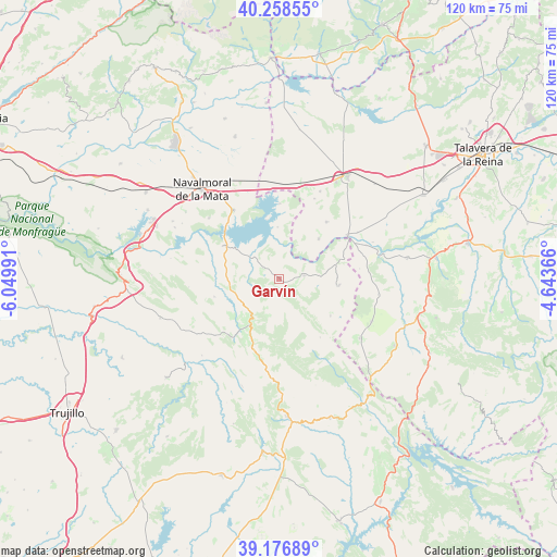
Garvín GPS coordinates[2]
39° 43' 11.424" North, 5° 20' 48.408" West
| Map corner | latitude | longitude |
|---|---|---|
| Upper-left | 40.25855°, | -6.04991° |
| Center: | 39.71984°, | -5.34678° |
| Lower-right: | 39.17689°, | -4.64366° |
| Map W x H: | 120.3×120.3 km | = 74.8×74.8mi |
| max Lat: | 43.74134° ⇑74% North |
| Garvín: | 39.71984° |
| min Lat: | ⇓26% South 27.64134° |
| min Long | Garvín | max Long |
| -18.00367° | -5.34678° | 4.2899° |
| W 23.2%⇐ | ⇒76.8% E |
Elevation
Elevation of Garvín is 502 m = 1647 ft, and this is 96 m = 315 ft below average elevation for this country.
| Max E: |
1682 m = 5518 ft | 61.8% |
| Avg. | 598 m = 1962 ft | |
| Garvín | 502 m = 1647 ft | |
Min E: |
0 m = 0 ft | 38.2% |
See also: Spain elevation on elevation.city.
Geographical zone
Garvín is located in North temperate zone (between Tropic of Cancer and the Arctic Circle). Distance of this Northern Tropic circle is 1810.5 km =1125 mi to South.| Distance of | km | miles | from Garvín |
|---|---|---|---|
| North Pole | 5590.6 | 3473.8 | to North |
| Arctic Circle | 2984.7 | 1854.6 | to North |
| Tropic Cancer | 1810.5 | 1125 | to South |
| Equator | 4416.4 | 2744.2 | to South |


Nearby cities:
15 places around Garvín: (largest is in red/bold)
• Berrocalejo
11.1 km =6.9 mi,  358°
358°
• Bohonal de Ibor
13.8 km =8.6 mi,  301°
301°
• Carrascalejo
14.7 km =9.1 mi,  130°
130°
• Castañar de Ibor
11.8 km =7.3 mi,  210°
210°
• El Puente del Arzobispo
17.5 km =10.9 mi,  58°
58°
• Fresnedoso de Ibor
14.4 km =8.9 mi,  254°
254°
• Mesas de Ibor
17.5 km =10.9 mi,  283°
283°
• Navalmoralejo
17.5 km =10.9 mi,  82°
82°
• Navalvillar de Ibor
16.2 km =10.1 mi,  200°
200°
• Peraleda de San Román
4.2 km =2.6 mi, 304°
• Peraleda de la Mata
17.7 km =11 mi,  326°
326°
• Torrico
16 km =9.9 mi,  40°
40°
• Valdelacasa de Tajo
5.5 km =3.4 mi, 82°
• Valdeverdeja
12.1 km =7.5 mi,  45°
45°
• Villar del Pedroso
13 km =8.1 mi,  96°
96°
Sources, notices
• [Note1] Compared only with cities in Spain existing in our database
• [Src1] Map data: © OpenStreetMap contributors (CC-BY-SA)
• [Src2] Other city data from geonames.org with taken over terms of usage.
• [Src3] Geographical zone / Annual Mean Temperature by Robert A. Rohde @ Wikipedia
