Cútar geodata
Cútar (Andalusia) is a seat of a third-order administrative division; located in Spain in Europe/Madrid (GMT+2) time zone. With population of 638 people, there are 3528 cities with bigger population in this country. Compared to other cities in Spain, 96.6% of cities are located further ↑North; 62.9% of cities are located further →East and 75% of cities have higher elevation than Cútar. Note1


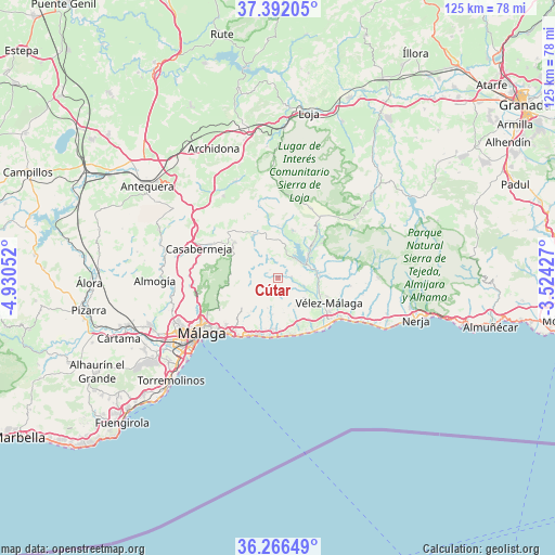
Cútar GPS coordinates[2]
36° 49' 52.824" North, 4° 13' 38.604" West
| Map corner | latitude | longitude |
|---|---|---|
| Upper-left | 37.39205°, | -4.93052° |
| Center: | 36.83134°, | -4.22739° |
| Lower-right: | 36.26649°, | -3.52427° |
| Map W x H: | 125.2×125.2 km | = 77.8×77.8mi |
| max Lat: | 43.74134° ⇑96.6% North |
| Cútar: | 36.83134° |
| min Lat: | ⇓3.4% South 27.64134° |
| min Long | Cútar | max Long |
| -18.00367° | -4.22739° | 4.2899° |
| W 37.1%⇐ | ⇒62.9% E |
Elevation
Elevation of Cútar is 296 m = 971 ft, and this is 302 m = 991 ft below average elevation for this country.
| Max E: |
1682 m = 5518 ft | 75% |
| Avg. | 598 m = 1962 ft | |
| Cútar | 296 m = 971 ft | |
Min E: |
0 m = 0 ft | 25% |
See also: Spain elevation on elevation.city.
Geographical zone
Cútar is located in North temperate zone (between Tropic of Cancer and the Arctic Circle). Distance of this Northern Tropic circle is 1489.3 km =925.4 mi to South.| Distance of | km | miles | from Cútar |
|---|---|---|---|
| North Pole | 5911.8 | 3673.4 | to North |
| Arctic Circle | 3305.9 | 2054.2 | to North |
| Tropic Cancer | 1489.3 | 925.4 | to South |
| Equator | 4095.3 | 2544.7 | to South |


Nearby cities:
15 places around Cútar: (largest is in red/bold)
• Alcaucín
12.9 km =8 mi,  51°
51°
• Almáchar
2.7 km =1.7 mi,  158°
158°
• Benamargosa
3 km =1.9 mi,  82°
82°
• Benamocarra
7.4 km =4.6 mi,  127°
127°
• Borge
2 km =1.2 mi,  200°
200°
• Colmenar
12.7 km =7.9 mi,  310°
310°
• Comares
2.6 km =1.6 mi,  319°
319°
• Iznate
6.6 km =4.1 mi,  143°
143°
• Moclinejo
7.1 km =4.4 mi, 200°
• Periana
11.3 km =7 mi,  16°
16°
• Ríogordo
11.2 km =7 mi,  328°
328°
• Totalán
9.6 km =6 mi,  220°
220°
• Valdés
8.2 km =5.1 mi,  189°
189°
• Viñuela
8.4 km =5.2 mi,  65°
65°
• Vélez-Málaga
12.4 km =7.7 mi,  116°
116°
Sources, notices
• [Note1] Compared only with cities in Spain existing in our database
• [Src1] Map data: © OpenStreetMap contributors (CC-BY-SA)
• [Src2] Other city data from geonames.org with taken over terms of usage.
• [Src3] Geographical zone / Annual Mean Temperature by Robert A. Rohde @ Wikipedia
