Comares geodata
Comares (Andalusia) is a seat of a third-order administrative division; located in Spain in Europe/Madrid (GMT+2) time zone. With population of 1,463 people, there are 2494 cities with bigger population in this country. Compared to other cities in Spain, 96.4% of cities are located further ↑North; 63.2% of cities are located further →East and 53.9% of cities have lower elevation than Comares. Note1


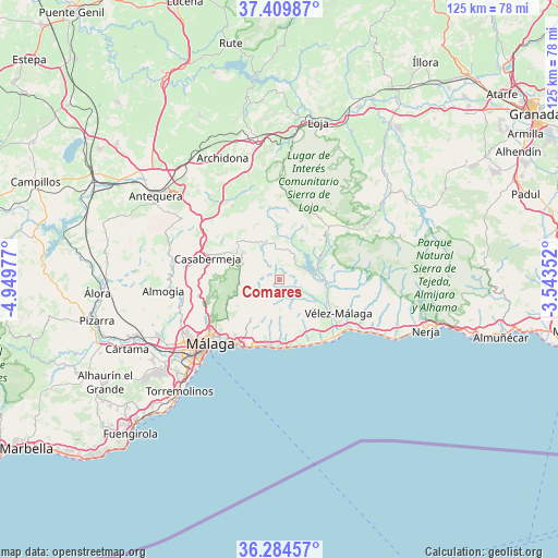
Comares GPS coordinates[2]
36° 50' 57.444" North, 4° 14' 47.904" West
| Map corner | latitude | longitude |
|---|---|---|
| Upper-left | 37.40987°, | -4.94977° |
| Center: | 36.84929°, | -4.24664° |
| Lower-right: | 36.28457°, | -3.54352° |
| Map W x H: | 125.1×125.1 km | = 77.7×77.7mi |
| max Lat: | 43.74134° ⇑96.4% North |
| Comares: | 36.84929° |
| min Lat: | ⇓3.6% South 27.64134° |
| min Long | Comares | max Long |
| -18.00367° | -4.24664° | 4.2899° |
| W 36.8%⇐ | ⇒63.2% E |
Elevation
Elevation of Comares is 700 m = 2297 ft, and this is 102 m = 335 ft above average elevation for this country.
| Max E: |
1682 m = 5518 ft | 46.1% |
| Comares | 700 m 2297 ft | |
| Avg. | 598 m = 1962 ft | |
Min E: |
0 m = 0 ft | 53.9% |
See also: Spain elevation on elevation.city.
Geographical zone
Comares is located in North temperate zone (between Tropic of Cancer and the Arctic Circle). Distance of this Northern Tropic circle is 1491.3 km =926.7 mi to South.| Distance of | km | miles | from Comares |
|---|---|---|---|
| North Pole | 5909.8 | 3672.2 | to North |
| Arctic Circle | 3303.9 | 2052.9 | to North |
| Tropic Cancer | 1491.3 | 926.7 | to South |
| Equator | 4097.3 | 2545.9 | to South |


Nearby cities:
15 places around Comares: (largest is in red/bold)
• Alcaucín
13.2 km =8.2 mi,  63°
63°
• Almáchar
5.2 km =3.2 mi,  148°
148°
• Benamargosa
5 km =3.1 mi,  108°
108°
• Benamocarra
10 km =6.2 mi,  130°
130°
• Borge
4 km =2.5 mi,  165°
165°
• Canillas de Aceituno
14.8 km =9.2 mi,  79°
79°
• Colmenar
10.1 km =6.3 mi,  308°
308°
• Cútar
2.6 km =1.6 mi,  139°
139°
• Iznate
9.2 km =5.7 mi, 142°
• Moclinejo
8.7 km =5.4 mi,  184°
184°
• Periana
10.2 km =6.3 mi,  28°
28°
• Ríogordo
8.6 km =5.3 mi,  331°
331°
• Totalán
10.4 km =6.5 mi,  205°
205°
• Valdés
10.1 km =6.3 mi, 177°
• Viñuela
9.5 km =5.9 mi, 80°
Sources, notices
• [Note1] Compared only with cities in Spain existing in our database
• [Src1] Map data: © OpenStreetMap contributors (CC-BY-SA)
• [Src2] Other city data from geonames.org with taken over terms of usage.
• [Src3] Geographical zone / Annual Mean Temperature by Robert A. Rohde @ Wikipedia
