Belmontejo geodata
Belmontejo (Castille-La Mancha) is a seat of a third-order administrative division; located in Spain in Europe/Madrid (GMT+2) time zone. With population of 201 people, there are 5031 cities with bigger population in this country. Compared to other cities in Spain, 72.6% of cities are located further ↑North; 62.9% of cities are located further ←West and 76% of cities have lower elevation than Belmontejo. Note1
Administrative division(s):
- Level 1: Castille-La Mancha
- Level 2: Provincia de Cuenca
- Level 3: Belmontejo


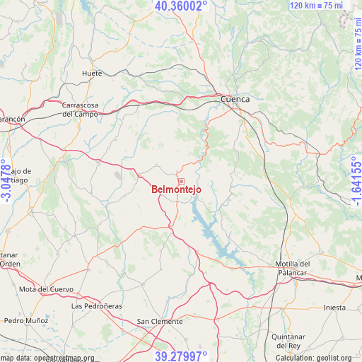
Belmontejo GPS coordinates[2]
39° 49' 19.632" North, 2° 20' 40.812" West
| Map corner | latitude | longitude |
|---|---|---|
| Upper-left | 40.36002°, | -3.0478° |
| Center: | 39.82212°, | -2.34467° |
| Lower-right: | 39.27997°, | -1.64155° |
| Map W x H: | 120.1×120.1 km | = 74.6×74.6mi |
| max Lat: | 43.74134° ⇑72.6% North |
| Belmontejo: | 39.82212° |
| min Lat: | ⇓27.4% South 27.64134° |
| min Long | Belmontejo | max Long |
| -18.00367° | -2.34467° | 4.2899° |
| W 62.9%⇐ | ⇒37.1% E |
Elevation
Elevation of Belmontejo is 860 m = 2822 ft, and this is 262 m = 860 ft above average elevation for this country.
| Max E: |
1682 m = 5518 ft | 24% |
| Belmontejo | 860 m 2822 ft | |
| Avg. | 598 m = 1962 ft | |
Min E: |
0 m = 0 ft | 76% |
See also: Spain elevation on elevation.city.
Geographical zone
Belmontejo is located in North temperate zone (between Tropic of Cancer and the Arctic Circle). Distance of this Northern Tropic circle is 1821.9 km =1132.1 mi to South.| Distance of | km | miles | from Belmontejo |
|---|---|---|---|
| North Pole | 5579.3 | 3466.8 | to North |
| Arctic Circle | 2973.4 | 1847.6 | to North |
| Tropic Cancer | 1821.9 | 1132.1 | to South |
| Equator | 4427.8 | 2751.3 | to South |


Nearby cities:
15 places around Belmontejo: (largest is in red/bold)
• Albaladejo del Cuende
10 km =6.2 mi,  99°
99°
• Altarejos
10.1 km =6.3 mi,  354°
354°
• Castillo de Garcimuñoz
18.4 km =11.4 mi,  189°
189°
• Cervera del Llano
7.8 km =4.8 mi,  236°
236°
• Fresneda de Altarejos
11.8 km =7.3 mi,  12°
12°
• La Almarcha
15.4 km =9.6 mi, 191°
• Montalbanejo
16.5 km =10.3 mi,  233°
233°
• Mota de Altarejos
7.3 km =4.5 mi,  24°
24°
• Olivares de Júcar
6.9 km =4.3 mi, 188°
• San Lorenzo de la Parrilla
3.5 km =2.2 mi,  337°
337°
• Torrubia del Castillo
18.4 km =11.4 mi,  171°
171°
• Valverde de Júcar
15.6 km =9.7 mi,  137°
137°
• Villarejo-Periesteban
10 km =6.2 mi,  304°
304°
• Villares del Saz
13.8 km =8.6 mi,  278°
278°
• Villaverde y Pasaconsol
8.8 km =5.5 mi,  130°
130°
Sources, notices
• [Note1] Compared only with cities in Spain existing in our database
• [Src1] Map data: © OpenStreetMap contributors (CC-BY-SA)
• [Src2] Other city data from geonames.org with taken over terms of usage.
• [Src3] Geographical zone / Annual Mean Temperature by Robert A. Rohde @ Wikipedia
