Onda geodata
Onda (Valencia) is a seat of a third-order administrative division; located in Spain in Europe/Madrid (GMT+1) time zone. With population of 25,691 people, there are 368 cities with bigger population in this country. Compared to other cities in Spain, 70.8% of cities are located further ↑North; 85% of cities are located further ←West and 81.7% of cities have higher elevation than Onda. Note1


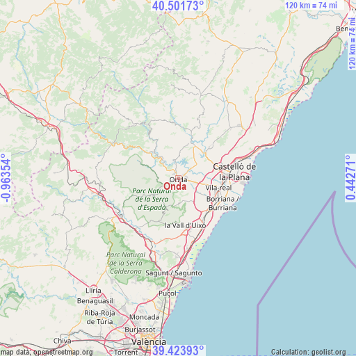
Onda GPS coordinates[2]
39° 57' 53.82" North, 0° 15' 37.476" West
| Map corner | latitude | longitude |
|---|---|---|
| Upper-left | 40.50173°, | -0.96354° |
| Center: | 39.96495°, | -0.26041° |
| Lower-right: | 39.42393°, | 0.44271° |
| Map W x H: | 119.8×119.8 km | = 74.4×74.4mi |
| max Lat: | 43.74134° ⇑70.8% North |
| Onda: | 39.96495° |
| min Lat: | ⇓29.2% South 27.64134° |
| min Long | Onda | max Long |
| -18.00367° | -0.26041° | 4.2899° |
| W 85%⇐ | ⇒15% E |
Elevation
Elevation of Onda is 192 m = 630 ft, and this is 406 m = 1332 ft below average elevation for this country.
| Max E: |
1682 m = 5518 ft | 81.7% |
| Avg. | 598 m = 1962 ft | |
| Onda | 192 m = 630 ft | |
Min E: |
0 m = 0 ft | 18.3% |
See also: Spain elevation on elevation.city.
Geographical zone
Onda is located in North temperate zone (between Tropic of Cancer and the Arctic Circle). Distance of this Northern Tropic circle is 1837.8 km =1142 mi to South.| Distance of | km | miles | from Onda |
|---|---|---|---|
| North Pole | 5563.4 | 3456.9 | to North |
| Arctic Circle | 2957.5 | 1837.7 | to North |
| Tropic Cancer | 1837.8 | 1142 | to South |
| Equator | 4443.7 | 2761.2 | to South |


Nearby cities:
15 places around Onda: (largest is in red/bold)
• Alcudia de Veo
9.3 km =5.8 mi,  234°
234°
• Alquerías del Niño Perdido
13.6 km =8.5 mi,  124°
124°
• Argelita
12.2 km =7.6 mi,  321°
321°
• Artana
8.2 km =5.1 mi,  178°
178°
• Ayódar
9.9 km =6.2 mi,  293°
293°
• Betxí
6.2 km =3.9 mi, 124°
• Chóvar
13.7 km =8.5 mi,  200°
200°
• Eslida
9.7 km =6 mi, 200°
• Espadilla
10.8 km =6.7 mi,  314°
314°
• Fanzara
7.5 km =4.7 mi, 320°
• Ribesalbes
5.8 km =3.6 mi,  354°
354°
• Tales
4.4 km =2.7 mi,  245°
245°
• Toga
13.1 km =8.1 mi, 316°
• Villamalur
11.9 km =7.4 mi,  270°
270°
• l'Alcora
12.4 km =7.7 mi,  24°
24°
Sources, notices
• [Note1] Compared only with cities in Spain existing in our database
• [Src1] Map data: © OpenStreetMap contributors (CC-BY-SA)
• [Src2] Other city data from geonames.org with taken over terms of usage.
• [Src3] Geographical zone / Annual Mean Temperature by Robert A. Rohde @ Wikipedia
