Almegíjar geodata
Almegíjar (Andalusia) is a seat of a third-order administrative division; located in Spain in Europe/Madrid (GMT+2) time zone. With population of 479 people, there are 3937 cities with bigger population in this country. Compared to other cities in Spain, 96.1% of cities are located further ↑North; 50.4% of cities are located further ←West and 70.6% of cities have lower elevation than Almegíjar. Note1


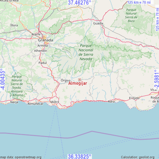
Almegíjar GPS coordinates[2]
36° 54' 9.288" North, 3° 18' 4.392" West
| Map corner | latitude | longitude |
|---|---|---|
| Upper-left | 37.46276°, | -4.00435° |
| Center: | 36.90258°, | -3.30122° |
| Lower-right: | 36.33825°, | -2.5981° |
| Map W x H: | 125×125 km | = 77.7×77.7mi |
| max Lat: | 43.74134° ⇑96.1% North |
| Almegíjar: | 36.90258° |
| min Lat: | ⇓3.9% South 27.64134° |
| min Long | Almegíjar | max Long |
| -18.00367° | -3.30122° | 4.2899° |
| W 50.4%⇐ | ⇒49.6% E |
Elevation
Elevation of Almegíjar is 818 m = 2684 ft, and this is 220 m = 722 ft above average elevation for this country.
| Max E: |
1682 m = 5518 ft | 29.4% |
| Almegíjar | 818 m 2684 ft | |
| Avg. | 598 m = 1962 ft | |
Min E: |
0 m = 0 ft | 70.6% |
See also: Spain elevation on elevation.city.
Geographical zone
Almegíjar is located in North temperate zone (between Tropic of Cancer and the Arctic Circle). Distance of this Northern Tropic circle is 1497.3 km =930.4 mi to South.| Distance of | km | miles | from Almegíjar |
|---|---|---|---|
| North Pole | 5903.9 | 3668.5 | to North |
| Arctic Circle | 3298 | 2049.3 | to North |
| Tropic Cancer | 1497.3 | 930.4 | to South |
| Equator | 4103.2 | 2549.6 | to South |


Nearby cities:
15 places around Almegíjar: (largest is in red/bold)
• Albondón
11.5 km =7.1 mi,  136°
136°
• Bubión
7.1 km =4.4 mi,  316°
316°
• Busquístar
4 km =2.5 mi,  8°
8°
• Capileira
8.3 km =5.2 mi, 322°
• Carataunas
9.8 km =6.1 mi,  282°
282°
• Cástaras
5.3 km =3.3 mi,  52°
52°
• Cáñar
11.6 km =7.2 mi, 283°
• Juviles
8.4 km =5.2 mi, 52°
• Lobras
8.4 km =5.2 mi,  69°
69°
• Pampaneira
6.8 km =4.2 mi,  308°
308°
• Pórtugos
4.5 km =2.8 mi,  349°
349°
• Rubite
11.2 km =7 mi,  201°
201°
• Soportújar
9.7 km =6 mi,  287°
287°
• Trevélez
11.3 km =7 mi,  16°
16°
• Órgiva
10.9 km =6.8 mi,  270°
270°
Sources, notices
• [Note1] Compared only with cities in Spain existing in our database
• [Src1] Map data: © OpenStreetMap contributors (CC-BY-SA)
• [Src2] Other city data from geonames.org with taken over terms of usage.
• [Src3] Geographical zone / Annual Mean Temperature by Robert A. Rohde @ Wikipedia
