Soportújar geodata
Soportújar (Andalusia) is a seat of a third-order administrative division; located in Spain in Europe/Madrid (GMT+2) time zone. With population of 273 people, there are 4613 cities with bigger population in this country. Compared to other cities in Spain, 95.9% of cities are located further ↑North; 50.8% of cities are located further →East and 84.9% of cities have lower elevation than Soportújar. Note1


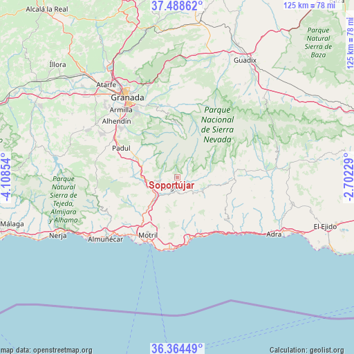
Soportújar GPS coordinates[2]
36° 55' 43.068" North, 3° 24' 19.512" West
| Map corner | latitude | longitude |
|---|---|---|
| Upper-left | 37.48862°, | -4.10854° |
| Center: | 36.92863°, | -3.40542° |
| Lower-right: | 36.36449°, | -2.70229° |
| Map W x H: | 125×125 km | = 77.7×77.7mi |
| max Lat: | 43.74134° ⇑95.9% North |
| Soportújar: | 36.92863° |
| min Lat: | ⇓4.1% South 27.64134° |
| min Long | Soportújar | max Long |
| -18.00367° | -3.40542° | 4.2899° |
| W 49.2%⇐ | ⇒50.8% E |
Elevation
Elevation of Soportújar is 950 m = 3117 ft, and this is 352 m = 1155 ft above average elevation for this country.
| Max E: |
1682 m = 5518 ft | 15.1% |
| Soportújar | 950 m 3117 ft | |
| Avg. | 598 m = 1962 ft | |
Min E: |
0 m = 0 ft | 84.9% |
See also: Spain elevation on elevation.city.
Geographical zone
Soportújar is located in North temperate zone (between Tropic of Cancer and the Arctic Circle). Distance of this Northern Tropic circle is 1500.2 km =932.2 mi to South.| Distance of | km | miles | from Soportújar |
|---|---|---|---|
| North Pole | 5901 | 3666.7 | to North |
| Arctic Circle | 3295.1 | 2047.5 | to North |
| Tropic Cancer | 1500.2 | 932.2 | to South |
| Equator | 4106.1 | 2551.4 | to South |


Nearby cities:
15 places around Soportújar: (largest is in red/bold)
• Almegíjar
9.7 km =6 mi,  107°
107°
• Bubión
4.9 km =3 mi,  62°
62°
• Busquístar
9.9 km =6.2 mi,  83°
83°
• Capileira
5.5 km =3.4 mi,  48°
48°
• Carataunas
0.8 km =0.5 mi,  199°
199°
• Cástaras
13.5 km =8.4 mi,  88°
88°
• Cáñar
2 km =1.2 mi,  264°
264°
• Lanjarón
6.9 km =4.3 mi, 260°
• Nigüelas
13.1 km =8.1 mi,  294°
294°
• Pampaneira
4.2 km =2.6 mi,  72°
72°
• Pórtugos
8.6 km =5.3 mi, 80°
• Rubite
14.2 km =8.8 mi,  158°
158°
• Trevélez
14.8 km =9.2 mi, 57°
• Vélez de Benaudalla
14.5 km =9 mi,  222°
222°
• Órgiva
3.3 km =2.1 mi,  209°
209°
Sources, notices
• [Note1] Compared only with cities in Spain existing in our database
• [Src1] Map data: © OpenStreetMap contributors (CC-BY-SA)
• [Src2] Other city data from geonames.org with taken over terms of usage.
• [Src3] Geographical zone / Annual Mean Temperature by Robert A. Rohde @ Wikipedia
