Rubite geodata
Rubite (Andalusia) is a seat of a third-order administrative division; located in Spain in Europe/Madrid (GMT+2) time zone. With population of 507 people, there are 3865 cities with bigger population in this country. Compared to other cities in Spain, 96.7% of cities are located further ↑North; 50.1% of cities are located further →East and 66.9% of cities have lower elevation than Rubite. Note1


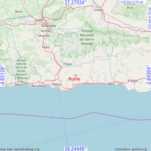
Rubite GPS coordinates[2]
36° 48' 34.092" North, 3° 20' 53.376" West
| Map corner | latitude | longitude |
|---|---|---|
| Upper-left | 37.37034°, | -4.05129° |
| Center: | 36.80947°, | -3.34816° |
| Lower-right: | 36.24446°, | -2.64504° |
| Map W x H: | 125.2×125.2 km | = 77.8×77.8mi |
| max Lat: | 43.74134° ⇑96.7% North |
| Rubite: | 36.80947° |
| min Lat: | ⇓3.3% South 27.64134° |
| min Long | Rubite | max Long |
| -18.00367° | -3.34816° | 4.2899° |
| W 49.9%⇐ | ⇒50.1% E |
Elevation
Elevation of Rubite is 791 m = 2595 ft, and this is 193 m = 633 ft above average elevation for this country.
| Max E: |
1682 m = 5518 ft | 33.1% |
| Rubite | 791 m 2595 ft | |
| Avg. | 598 m = 1962 ft | |
Min E: |
0 m = 0 ft | 66.9% |
See also: Spain elevation on elevation.city.
Geographical zone
Rubite is located in North temperate zone (between Tropic of Cancer and the Arctic Circle). Distance of this Northern Tropic circle is 1486.9 km =923.9 mi to South.| Distance of | km | miles | from Rubite |
|---|---|---|---|
| North Pole | 5914.2 | 3674.9 | to North |
| Arctic Circle | 3308.3 | 2055.7 | to North |
| Tropic Cancer | 1486.9 | 923.9 | to South |
| Equator | 4092.8 | 2543.1 | to South |


Nearby cities:
15 places around Rubite: (largest is in red/bold)
• Albondón
12.3 km =7.6 mi,  80°
80°
• Albuñol
12.9 km =8 mi,  98°
98°
• Almegíjar
11.2 km =7 mi,  21°
21°
• Busquístar
15.1 km =9.4 mi, 18°
• Carataunas
13.6 km =8.5 mi,  336°
336°
• Castell de Ferro
9.3 km =5.8 mi,  183°
183°
• Cáñar
14.9 km =9.3 mi,  331°
331°
• Gualchos
8.1 km =5 mi,  207°
207°
• Lújar
5.5 km =3.4 mi,  244°
244°
• Pampaneira
14.6 km =9.1 mi,  355°
355°
• Polopos
4.7 km =2.9 mi,  110°
110°
• Pórtugos
15.1 km =9.4 mi,  12°
12°
• Soportújar
14.2 km =8.8 mi, 338°
• Sorvilán
7.3 km =4.5 mi, 102°
• Órgiva
12.3 km =7.6 mi, 326°
Sources, notices
• [Note1] Compared only with cities in Spain existing in our database
• [Src1] Map data: © OpenStreetMap contributors (CC-BY-SA)
• [Src2] Other city data from geonames.org with taken over terms of usage.
• [Src3] Geographical zone / Annual Mean Temperature by Robert A. Rohde @ Wikipedia
