Adeje geodata
Adeje (Canary Islands) is a seat of a third-order administrative division; located in Spain in Atlantic/Canary (GMT+1) time zone. With population of 43,204 people, there are 205 cities with bigger population in this country. Compared to other cities in Spain, 99.5% of cities are located further ↑North; 99.5% of cities are located further →East and 76.1% of cities have higher elevation than Adeje. Note1
Administrative division(s):
- Level 1: Canary Islands
- Level 2: Provincia de Santa Cruz de Tenerife
- Level 3: Adeje


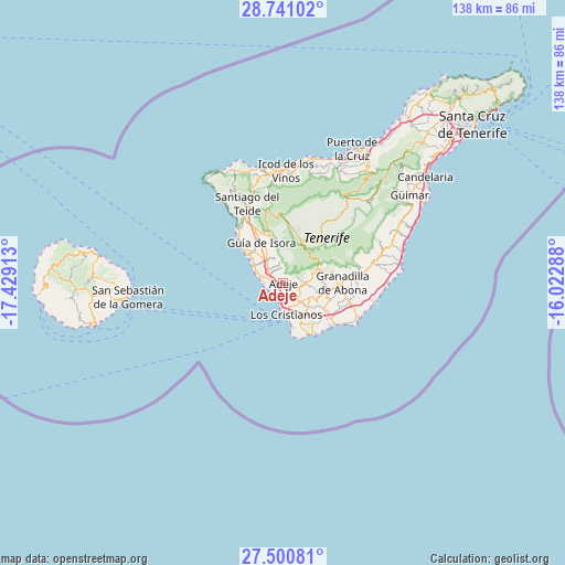
Adeje GPS coordinates[2]
28° 7' 21.756" North, 16° 43' 33.6" West
| Map corner | latitude | longitude |
|---|---|---|
| Upper-left | 28.74102°, | -17.42913° |
| Center: | 28.12271°, | -16.726° |
| Lower-right: | 27.50081°, | -16.02288° |
| Map W x H: | 137.9×137.9 km | = 85.7×85.7mi |
| max Lat: | 43.74134° ⇑99.5% North |
| Adeje: | 28.12271° |
| min Lat: | ⇓0.5% South 27.64134° |
| min Long | Adeje | max Long |
| -18.00367° | -16.726° | 4.2899° |
| W 0.5%⇐ | ⇒99.5% E |
Elevation
Elevation of Adeje is 284 m = 932 ft, and this is 314 m = 1030 ft below average elevation for this country.
| Max E: |
1682 m = 5518 ft | 76.1% |
| Avg. | 598 m = 1962 ft | |
| Adeje | 284 m = 932 ft | |
Min E: |
0 m = 0 ft | 23.9% |
See also: Adeje elevation on elevation.city.
Geographical zone
Adeje is located in North temperate zone (between Tropic of Cancer and the Arctic Circle). Distance of this Northern Tropic circle is 521 km =323.7 mi to South.| Distance of | km | miles | from Adeje |
|---|---|---|---|
| North Pole | 6880.1 | 4275.1 | to North |
| Arctic Circle | 4274.2 | 2655.9 | to North |
| Tropic Cancer | 521 | 323.7 | to South |
| Equator | 3127 | 1943 | to South |


Nearby cities:
15 places around Adeje: (largest is in red/bold)
• Arona
5.1 km =3.2 mi,  120°
120°
• El Médano
20.5 km =12.7 mi,  114°
114°
• Granadilla de Abona
14.7 km =9.1 mi,  91°
91°
• Guía de Isora
11.2 km =7 mi,  332°
332°
• Icod de los Vinos
27.8 km =17.3 mi,  2°
2°
• La Estrella
14.1 km =8.8 mi,  150°
150°
• Las Rosas
13.9 km =8.6 mi, 149°
• Lomo de Arico
24.3 km =15.1 mi,  78°
78°
• Los Gigantes
17.6 km =10.9 mi,  319°
319°
• Playa de las Américas
6.5 km =4 mi,  183°
183°
• Puerto de Santiago
17.1 km =10.6 mi, 317°
• San Isidro
17.3 km =10.7 mi, 107°
• San Miguel De Abona
11 km =6.8 mi,  104°
104°
• Santiago del Teide
21 km =13 mi,  335°
335°
• Vilaflor
9.6 km =6 mi,  67°
67°
Sources, notices
• [Note1] Compared only with cities in Spain existing in our database
• [Src1] Map data: © OpenStreetMap contributors (CC-BY-SA)
• [Src2] Other city data from geonames.org with taken over terms of usage.
• [Src3] Geographical zone / Annual Mean Temperature by Robert A. Rohde @ Wikipedia
