Arona geodata
Arona (Canary Islands) is a seat of a third-order administrative division; located in Spain in Atlantic/Canary (GMT+1) time zone. With population of 78,614 people, there are 118 cities with bigger population in this country. Compared to other cities in Spain, 99.6% of cities are located further ↑North; 99.5% of cities are located further →East and 52.4% of cities have higher elevation than Arona. Note1
Administrative division(s):
- Level 1: Canary Islands
- Level 2: Provincia de Santa Cruz de Tenerife
- Level 3: Arona


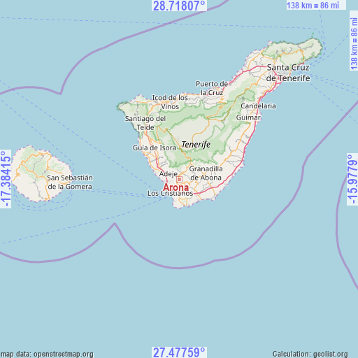
Arona GPS coordinates[2]
28° 5' 58.632" North, 16° 40' 51.672" West
| Map corner | latitude | longitude |
|---|---|---|
| Upper-left | 28.71807°, | -17.38415° |
| Center: | 28.09962°, | -16.68102° |
| Lower-right: | 27.47759°, | -15.9779° |
| Map W x H: | 137.9×137.9 km | = 85.7×85.7mi |
| max Lat: | 43.74134° ⇑99.6% North |
| Arona: | 28.09962° |
| min Lat: | ⇓0.4% South 27.64134° |
| min Long | Arona | max Long |
| -18.00367° | -16.68102° | 4.2899° |
| W 0.5%⇐ | ⇒99.5% E |
Elevation
Elevation of Arona is 632 m = 2073 ft, and this is 34 m = 112 ft above average elevation for this country.
| Max E: |
1682 m = 5518 ft | 52.4% |
| Arona | 632 m 2073 ft | |
| Avg. | 598 m = 1962 ft | |
Min E: |
0 m = 0 ft | 47.6% |
See also: Arona elevation on elevation.city.
Geographical zone
Arona is located in North temperate zone (between Tropic of Cancer and the Arctic Circle). Distance of this Northern Tropic circle is 518.5 km =322.2 mi to South.| Distance of | km | miles | from Arona |
|---|---|---|---|
| North Pole | 6882.7 | 4276.7 | to North |
| Arctic Circle | 4276.8 | 2657.5 | to North |
| Tropic Cancer | 518.5 | 322.2 | to South |
| Equator | 3124.4 | 1941.4 | to South |


Nearby cities:
15 places around Arona: (largest is in red/bold)
• Adeje
5.1 km =3.2 mi,  300°
300°
• El Médano
15.4 km =9.6 mi,  112°
112°
• Fasnia
28.2 km =17.5 mi,  57°
57°
• Granadilla de Abona
10.5 km =6.5 mi,  78°
78°
• Guía de Isora
15.7 km =9.8 mi,  322°
322°
• La Estrella
10 km =6.2 mi,  164°
164°
• Las Rosas
9.7 km =6 mi, 164°
• Lomo de Arico
20.8 km =12.9 mi,  68°
68°
• Los Gigantes
22.4 km =13.9 mi, 315°
• Playa de las Américas
6.2 km =3.9 mi,  230°
230°
• Puerto de Santiago
22 km =13.7 mi,  313°
313°
• San Isidro
12.3 km =7.6 mi,  102°
102°
• San Miguel De Abona
6.3 km =3.9 mi,  91°
91°
• Santiago del Teide
25.3 km =15.7 mi,  328°
328°
• Vilaflor
7.7 km =4.8 mi,  35°
35°
Sources, notices
• [Note1] Compared only with cities in Spain existing in our database
• [Src1] Map data: © OpenStreetMap contributors (CC-BY-SA)
• [Src2] Other city data from geonames.org with taken over terms of usage.
• [Src3] Geographical zone / Annual Mean Temperature by Robert A. Rohde @ Wikipedia
