Playa de las Américas geodata
Playa de las Américas (Canary Islands) is a populated place; located in Spain in Atlantic/Canary (GMT+1) time zone. With population of 3,000 people, there are 1721 cities with bigger population in this country. Compared to other cities in Spain, 99.6% of cities are located further ↑North; 99.6% of cities are located further →East and 97.3% of cities have higher elevation than Playa de las Américas. Note1
Administrative division(s):
- Level 1: Canary Islands
- Level 2: Provincia de Santa Cruz de Tenerife
- Level 3: Adeje
Current local time in Playa de las Américas:
09:43 PM, ThursdayDifference from your time zone: hours


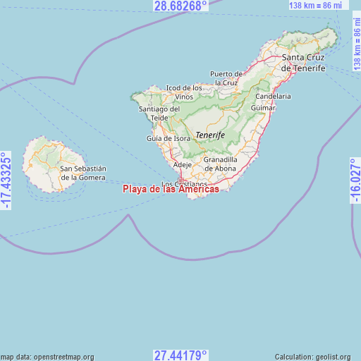
Playa de las Américas GPS coordinates[2]
28° 3' 50.508" North, 16° 43' 48.432" West
| Map corner | latitude | longitude |
|---|---|---|
| Upper-left | 28.68268°, | -17.43325° |
| Center: | 28.06403°, | -16.73012° |
| Lower-right: | 27.44179°, | -16.027° |
| Map W x H: | 138×138 km | = 85.7×85.7mi |
| max Lat: | 43.74134° ⇑99.6% North |
| Playa de las Américas: | 28.06403° |
| min Lat: | ⇓0.4% South 27.64134° |
| min Long | Playa de las Am | max Long |
| -18.00367° | -16.73012° | 4.2899° |
| W 0.4%⇐ | ⇒99.6% E |
Elevation
Elevation of Playa de las Américas is 14 m = 46 ft, and this is 584 m = 1916 ft below average elevation for this country.
| Max E: |
1682 m = 5518 ft | 97.3% |
| Avg. | 598 m = 1962 ft | |
| Playa de las Américas | 14 m = 46 ft | |
Min E: |
0 m = 0 ft | 2.7% |
See also: Spain elevation on elevation.city.
Geographical zone
Playa de las Américas is located in North temperate zone (between Tropic of Cancer and the Arctic Circle). Distance of this Northern Tropic circle is 514.5 km =319.7 mi to South.| Distance of | km | miles | from Playa de las Américas |
|---|---|---|---|
| North Pole | 6886.6 | 4279.1 | to North |
| Arctic Circle | 4280.7 | 2659.9 | to North |
| Tropic Cancer | 514.5 | 319.7 | to South |
| Equator | 3120.4 | 1938.9 | to South |


Nearby cities:
15 places around Playa de las Américas: (largest is in red/bold)
• Adeje
6.5 km =4 mi,  3°
3°
• Arona
6.2 km =3.9 mi,  50°
50°
• El Médano
19.1 km =11.9 mi,  95°
95°
• Granadilla de Abona
16.3 km =10.1 mi,  68°
68°
• Guía de Isora
17.1 km =10.6 mi,  343°
343°
• Icod de los Vinos
34.3 km =21.3 mi, 2°
• La Estrella
9.4 km =5.8 mi,  127°
127°
• Las Rosas
9.2 km =5.7 mi, 125°
• Lomo de Arico
26.8 km =16.7 mi,  64°
64°
• Los Gigantes
22.8 km =14.2 mi,  331°
331°
• Puerto de Santiago
22.2 km =13.8 mi, 329°
• San Isidro
16.9 km =10.5 mi,  85°
85°
• San Miguel De Abona
11.7 km =7.3 mi, 71°
• Santiago del Teide
26.9 km =16.7 mi, 341°
• Vilaflor
13.8 km =8.6 mi,  42°
42°
Sources, notices
• [Note1] Compared only with cities in Spain existing in our database
• [Src1] Map data: © OpenStreetMap contributors (CC-BY-SA)
• [Src2] Other city data from geonames.org with taken over terms of usage.
• [Src3] Geographical zone / Annual Mean Temperature by Robert A. Rohde @ Wikipedia
