Zugarramurdi geodata
Zugarramurdi (Navarre) is a seat of a third-order administrative division; located in Spain in Europe/Madrid (GMT+2) time zone. With population of 227 people, there are 4876 cities with bigger population in this country. Compared to other cities in Spain, 97.2% of cities are located further ↓South; 72.5% of cities are located further ←West and 80.8% of cities have higher elevation than Zugarramurdi. Note1


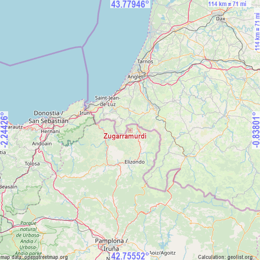
Zugarramurdi GPS coordinates[2]
43° 16' 10.704" North, 1° 32' 28.068" West
| Map corner | latitude | longitude |
|---|---|---|
| Upper-left | 43.77946°, | -2.24426° |
| Center: | 43.26964°, | -1.54113° |
| Lower-right: | 42.75552°, | -0.83801° |
| Map W x H: | 113.9×113.9 km | = 70.8×70.8mi |
| max Lat: | 43.74134° ⇑2.8% North |
| Zugarramurdi: | 43.26964° |
| min Lat: | ⇓97.2% South 27.64134° |
| min Long | Zugarramurdi | max Long |
| -18.00367° | -1.54113° | 4.2899° |
| W 72.5%⇐ | ⇒27.5% E |
Elevation
Elevation of Zugarramurdi is 206 m = 676 ft, and this is 392 m = 1286 ft below average elevation for this country.
| Max E: |
1682 m = 5518 ft | 80.8% |
| Avg. | 598 m = 1962 ft | |
| Zugarramurdi | 206 m = 676 ft | |
Min E: |
0 m = 0 ft | 19.2% |
See also: Spain elevation on elevation.city.
Geographical zone
Zugarramurdi is located in North temperate zone (between Tropic of Cancer and the Arctic Circle). Distance of this Northern Tropic circle is 2205.2 km =1370.2 mi to South.| Distance of | km | miles | from Zugarramurdi |
|---|---|---|---|
| North Pole | 5195.9 | 3228.6 | to North |
| Arctic Circle | 2590 | 1609.4 | to North |
| Tropic Cancer | 2205.2 | 1370.2 | to South |
| Equator | 4811.1 | 2989.5 | to South |


Nearby cities:
15 places around Zugarramurdi: (largest is in red/bold)
• Arantza
17 km =10.6 mi,  241°
241°
• Bera
11.8 km =7.3 mi,  276°
276°
• Doneztebe
18.3 km =11.4 mi,  213°
213°
• Elgorriaga
18.7 km =11.6 mi,  218°
218°
• Etxalar
8.7 km =5.4 mi, 242°
• Goizueta
28.3 km =17.6 mi,  247°
247°
• Hondarribia
23.4 km =14.5 mi,  298°
298°
• Igantzi
13.8 km =8.6 mi, 249°
• Irun
21.5 km =13.4 mi,  291°
291°
• Ituren
21.1 km =13.1 mi, 223°
• Lesaka
13 km =8.1 mi,  260°
260°
• Oitz
20.5 km =12.7 mi, 214°
• Saldías
27.9 km =17.3 mi, 223°
• Sunbilla
15.3 km =9.5 mi, 221°
• Zubieta
22.9 km =14.2 mi,  225°
225°
Sources, notices
• [Note1] Compared only with cities in Spain existing in our database
• [Src1] Map data: © OpenStreetMap contributors (CC-BY-SA)
• [Src2] Other city data from geonames.org with taken over terms of usage.
• [Src3] Geographical zone / Annual Mean Temperature by Robert A. Rohde @ Wikipedia
