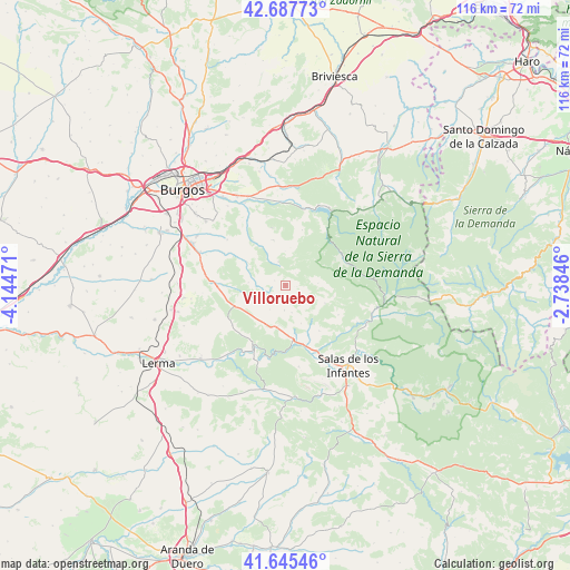
Villoruebo geodata
Villoruebo (Castille and León) is a seat of a third-order administrative division; located in Spain in Europe/Madrid (GMT+2) time zone. With population of 70 people, there are 6241 cities with bigger population in this country. Compared to other cities in Spain, 78.4% of cities are located further ↓South; 51.3% of cities are located further →East and 94.3% of cities have lower elevation than Villoruebo. Note1
Administrative division(s):
- Level 1: Castille and León
- Level 2: Provincia de Burgos
- Level 3: Villoruebo


Villoruebo GPS coordinates[2]
42° 10' 7.464" North, 3° 26' 29.724" West
| Map corner | latitude | longitude |
|---|---|---|
| Upper-left | 42.68773°, | -4.14471° |
| Center: | 42.16874°, | -3.44159° |
| Lower-right: | 41.64546°, | -2.73846° |
| Map W x H: | 115.9×115.9 km | = 72×72mi |
| max Lat: | 43.74134° ⇑21.6% North |
| Villoruebo: | 42.16874° |
| min Lat: | ⇓78.4% South 27.64134° |
| min Long | Villoruebo | max Long |
| -18.00367° | -3.44159° | 4.2899° |
| W 48.7%⇐ | ⇒51.3% E |
Elevation
Elevation of Villoruebo is 1122 m = 3681 ft, and this is 524 m = 1719 ft above average elevation for this country.
| Max E: |
1682 m = 5518 ft | 5.7% |
| Villoruebo | 1122 m 3681 ft | |
| Avg. | 598 m = 1962 ft | |
Min E: |
0 m = 0 ft | 94.3% |
See also: Spain elevation on elevation.city.
Geographical zone
Villoruebo is located in North temperate zone (between Tropic of Cancer and the Arctic Circle). Distance of this Northern Tropic circle is 2082.8 km =1294.2 mi to South.| Distance of | km | miles | from Villoruebo |
|---|---|---|---|
| North Pole | 5318.3 | 3304.6 | to North |
| Arctic Circle | 2712.4 | 1685.4 | to North |
| Tropic Cancer | 2082.8 | 1294.2 | to South |
| Equator | 4688.7 | 2913.4 | to South |


Nearby cities:
15 places around Villoruebo: (largest is in red/bold)
• Campolara
5.6 km =3.5 mi,  167°
167°
• Cascajares de la Sierra
12.4 km =7.7 mi,  163°
163°
• Cuevas de San Clemente
11.3 km =7 mi,  247°
247°
• Hortigüela
11.2 km =7 mi, 173°
• Jaramillo Quemado
11.5 km =7.1 mi,  143°
143°
• Jaramillo de la Fuente
12.2 km =7.6 mi,  119°
119°
• Mambrillas de Lara
8.4 km =5.2 mi,  191°
191°
• Palazuelos de la Sierra
5 km =3.1 mi,  342°
342°
• Pineda de la Sierra
13 km =8.1 mi,  66°
66°
• Revilla del Campo
9.6 km =6 mi,  299°
299°
• San Adrián de Juarros
12.1 km =7.5 mi,  346°
346°
• San Millán de Lara
8.7 km =5.4 mi,  114°
114°
• Torrelara
6.2 km =3.9 mi,  267°
267°
• Villaespasa
8.2 km =5.1 mi, 158°
• Villamiel de la Sierra
3.2 km =2 mi,  38°
38°
Sources, notices
• [Note1] Compared only with cities in Spain existing in our database
• [Src1] Map data: © OpenStreetMap contributors (CC-BY-SA)
• [Src2] Other city data from geonames.org with taken over terms of usage.
• [Src3] Geographical zone / Annual Mean Temperature by Robert A. Rohde @ Wikipedia
