Jaramillo de la Fuente geodata
Jaramillo de la Fuente (Castille and León) is a seat of a third-order administrative division; located in Spain in Europe/Madrid (GMT+2) time zone. With population of 52 people, there are 6440 cities with bigger population in this country. Compared to other cities in Spain, 76.8% of cities are located further ↓South; 50.3% of cities are located further ←West and 91.5% of cities have lower elevation than Jaramillo de la Fuente. Note1
Administrative division(s):
- Level 1: Castille and León
- Level 2: Provincia de Burgos
- Level 3: Jaramillo de la Fuente
Current local time in Jaramillo de la Fuente:
11:55 PM, ThursdayDifference from your time zone: hours


Jaramillo de la Fuente GPS coordinates[2]
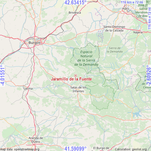
42° 6' 52.992" North, 3° 18' 44.604" West
| Map corner | latitude | longitude |
|---|---|---|
| Upper-left | 42.63415°, | -4.01551° |
| Center: | 42.11472°, | -3.31239° |
| Lower-right: | 41.59099°, | -2.60926° |
| Map W x H: | 116×116 km | = 72.1×72.1mi |
| max Lat: | 43.74134° ⇑23.2% North |
| Jaramillo de la Fuente: | 42.11472° |
| min Lat: | ⇓76.8% South 27.64134° |
| min Long | Jaramillo de la | max Long |
| -18.00367° | -3.31239° | 4.2899° |
| W 50.3%⇐ | ⇒49.7% E |
Elevation
Elevation of Jaramillo de la Fuente is 1057 m = 3468 ft, and this is 459 m = 1506 ft above average elevation for this country.
| Max E: |
1682 m = 5518 ft | 8.5% |
| Jaramillo de la Fuente | 1057 m 3468 ft | |
| Avg. | 598 m = 1962 ft | |
Min E: |
0 m = 0 ft | 91.5% |
See also: Spain elevation on elevation.city.
Geographical zone
Jaramillo de la Fuente is located in North temperate zone (between Tropic of Cancer and the Arctic Circle). Distance of this Northern Tropic circle is 2076.8 km =1290.5 mi to South.| Distance of | km | miles | from Jaramillo de la Fuente |
|---|---|---|---|
| North Pole | 5324.3 | 3308.4 | to North |
| Arctic Circle | 2718.5 | 1689.2 | to North |
| Tropic Cancer | 2076.8 | 1290.5 | to South |
| Equator | 4682.7 | 2909.7 | to South |


Nearby cities:
15 places around Jaramillo de la Fuente: (largest is in red/bold)
• Barbadillo de Herreros
11.8 km =7.3 mi,  70°
70°
• Barbadillo del Mercado
9.2 km =5.7 mi,  203°
203°
• Barbadillo del Pez
7 km =4.3 mi,  86°
86°
• Campolara
9.5 km =5.9 mi,  273°
273°
• Cascajares de la Sierra
9.3 km =5.8 mi,  230°
230°
• Hortigüela
10.7 km =6.6 mi,  241°
241°
• Jaramillo Quemado
5 km =3.1 mi, 229°
• Monasterio de la Sierra
12.1 km =7.5 mi,  125°
125°
• Pineda de la Sierra
11.3 km =7 mi,  6°
6°
• Pinilla de los Moros
5.3 km =3.3 mi,  193°
193°
• Riocavado de la Sierra
10.3 km =6.4 mi, 66°
• Salas de los Infantes
10.5 km =6.5 mi,  168°
168°
• San Millán de Lara
3.6 km =2.2 mi,  311°
311°
• Villaespasa
7.8 km =4.8 mi,  257°
257°
• Vizcaínos
3.9 km =2.4 mi,  108°
108°
Sources, notices
• [Note1] Compared only with cities in Spain existing in our database
• [Src1] Map data: © OpenStreetMap contributors (CC-BY-SA)
• [Src2] Other city data from geonames.org with taken over terms of usage.
• [Src3] Geographical zone / Annual Mean Temperature by Robert A. Rohde @ Wikipedia
