Hortigüela geodata
Hortigüela (Castille and León) is a seat of a third-order administrative division; located in Spain in Europe/Madrid (GMT+2) time zone. With population of 126 people, there are 5628 cities with bigger population in this country. Compared to other cities in Spain, 75.7% of cities are located further ↓South; 51.1% of cities are located further →East and 83.9% of cities have lower elevation than Hortigüela. Note1
Administrative division(s):
- Level 1: Castille and León
- Level 2: Provincia de Burgos
- Level 3: Hortigüela


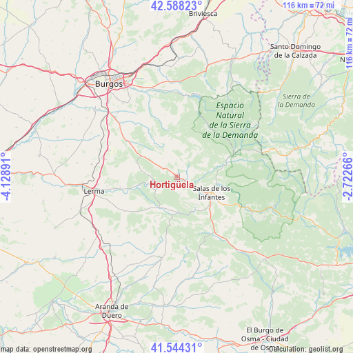
Hortigüela GPS coordinates[2]
42° 4' 6.312" North, 3° 25' 32.808" West
| Map corner | latitude | longitude |
|---|---|---|
| Upper-left | 42.58823°, | -4.12891° |
| Center: | 42.06842°, | -3.42578° |
| Lower-right: | 41.54431°, | -2.72266° |
| Map W x H: | 116.1×116.1 km | = 72.1×72.1mi |
| max Lat: | 43.74134° ⇑24.3% North |
| Hortigüela: | 42.06842° |
| min Lat: | ⇓75.7% South 27.64134° |
| min Long | Hortigüela | max Long |
| -18.00367° | -3.42578° | 4.2899° |
| W 48.9%⇐ | ⇒51.1% E |
Elevation
Elevation of Hortigüela is 940 m = 3084 ft, and this is 342 m = 1122 ft above average elevation for this country.
| Max E: |
1682 m = 5518 ft | 16.1% |
| Hortigüela | 940 m 3084 ft | |
| Avg. | 598 m = 1962 ft | |
Min E: |
0 m = 0 ft | 83.9% |
See also: Spain elevation on elevation.city.
Geographical zone
Hortigüela is located in North temperate zone (between Tropic of Cancer and the Arctic Circle). Distance of this Northern Tropic circle is 2071.7 km =1287.3 mi to South.| Distance of | km | miles | from Hortigüela |
|---|---|---|---|
| North Pole | 5329.5 | 3311.6 | to North |
| Arctic Circle | 2723.6 | 1692.4 | to North |
| Tropic Cancer | 2071.7 | 1287.3 | to South |
| Equator | 4677.6 | 2906.5 | to South |


Nearby cities:
15 places around Hortigüela: (largest is in red/bold)
• Barbadillo del Mercado
6.6 km =4.1 mi,  120°
120°
• Campolara
5.7 km =3.5 mi,  358°
358°
• Cascajares de la Sierra
2.3 km =1.4 mi,  108°
108°
• Contreras
5.5 km =3.4 mi,  167°
167°
• Covarrubias
7.8 km =4.8 mi,  262°
262°
• Jaramillo Quemado
5.9 km =3.7 mi,  70°
70°
• Jaramillo de la Fuente
10.7 km =6.6 mi,  61°
61°
• Mambrillas de Lara
4.2 km =2.6 mi,  314°
314°
• Pinilla de los Moros
8.1 km =5 mi,  90°
90°
• Retuerta
8 km =5 mi,  237°
237°
• San Millán de Lara
10.1 km =6.3 mi,  41°
41°
• Santibáñez del Val
11.5 km =7.1 mi,  203°
203°
• Santo Domingo de Silos
11.6 km =7.2 mi,  176°
176°
• Villaespasa
3.9 km =2.4 mi,  26°
26°
• Villoruebo
11.2 km =7 mi,  353°
353°
Sources, notices
• [Note1] Compared only with cities in Spain existing in our database
• [Src1] Map data: © OpenStreetMap contributors (CC-BY-SA)
• [Src2] Other city data from geonames.org with taken over terms of usage.
• [Src3] Geographical zone / Annual Mean Temperature by Robert A. Rohde @ Wikipedia
