Villaturiel geodata
Villaturiel (Castille and León) is a seat of a third-order administrative division; located in Spain in Europe/Madrid (GMT+2) time zone. With population of 1,748 people, there are 2315 cities with bigger population in this country. Compared to other cities in Spain, 87.7% of cities are located further ↓South; 78.5% of cities are located further →East and 67.9% of cities have lower elevation than Villaturiel. Note1
Administrative division(s):
- Level 1: Castille and León
- Level 2: Provincia de León
- Level 3: Villaturiel


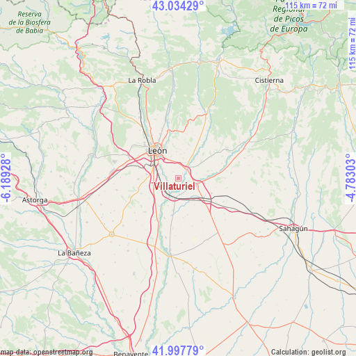
Villaturiel GPS coordinates[2]
42° 31' 5.484" North, 5° 29' 10.14" West
| Map corner | latitude | longitude |
|---|---|---|
| Upper-left | 43.03429°, | -6.18928° |
| Center: | 42.51819°, | -5.48615° |
| Lower-right: | 41.99779°, | -4.78303° |
| Map W x H: | 115.2×115.2 km | = 71.6×71.6mi |
| max Lat: | 43.74134° ⇑12.3% North |
| Villaturiel: | 42.51819° |
| min Lat: | ⇓87.7% South 27.64134° |
| min Long | Villaturiel | max Long |
| -18.00367° | -5.48615° | 4.2899° |
| W 21.5%⇐ | ⇒78.5% E |
Elevation
Elevation of Villaturiel is 798 m = 2618 ft, and this is 200 m = 656 ft above average elevation for this country.
| Max E: |
1682 m = 5518 ft | 32.1% |
| Villaturiel | 798 m 2618 ft | |
| Avg. | 598 m = 1962 ft | |
Min E: |
0 m = 0 ft | 67.9% |
See also: Spain elevation on elevation.city.
Geographical zone
Villaturiel is located in North temperate zone (between Tropic of Cancer and the Arctic Circle). Distance of this Northern Tropic circle is 2121.7 km =1318.4 mi to South.| Distance of | km | miles | from Villaturiel |
|---|---|---|---|
| North Pole | 5279.5 | 3280.5 | to North |
| Arctic Circle | 2673.6 | 1661.3 | to North |
| Tropic Cancer | 2121.7 | 1318.4 | to South |
| Equator | 4727.6 | 2937.6 | to South |


Nearby cities:
15 places around Villaturiel: (largest is in red/bold)
• Ardón
11 km =6.8 mi,  213°
213°
• Cabreros del Río
13.7 km =8.5 mi,  199°
199°
• Campo de Villavidel
9.4 km =5.8 mi, 201°
• Corbillos de los Oteros
12.5 km =7.8 mi,  169°
169°
• León
11.4 km =7.1 mi,  322°
322°
• Mansilla Mayor
3.7 km =2.3 mi,  105°
105°
• Mansilla de las Mulas
6 km =3.7 mi, 110°
• Onzonilla
7.9 km =4.9 mi,  275°
275°
• San Andrés del Rabanedo
14.9 km =9.3 mi,  314°
314°
• Santas Martas
13.5 km =8.4 mi,  135°
135°
• Valdefresno
8.6 km =5.3 mi,  355°
355°
• Valdevimbre
15.5 km =9.6 mi,  224°
224°
• Vega de Infanzones
5.6 km =3.5 mi, 222°
• Villanueva de las Manzanas
5.1 km =3.2 mi, 174°
• Villasabariego
6.2 km =3.9 mi,  74°
74°
Sources, notices
• [Note1] Compared only with cities in Spain existing in our database
• [Src1] Map data: © OpenStreetMap contributors (CC-BY-SA)
• [Src2] Other city data from geonames.org with taken over terms of usage.
• [Src3] Geographical zone / Annual Mean Temperature by Robert A. Rohde @ Wikipedia
