Onzonilla geodata
Onzonilla (Castille and León) is a seat of a third-order administrative division; located in Spain in Europe/Madrid (GMT+2) time zone. With population of 1,566 people, there are 2413 cities with bigger population in this country. Compared to other cities in Spain, 87.8% of cities are located further ↓South; 79.9% of cities are located further →East and 69.3% of cities have lower elevation than Onzonilla. Note1
Administrative division(s):
- Level 1: Castille and León
- Level 2: Provincia de León
- Level 3: Onzonilla


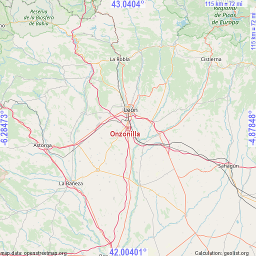
Onzonilla GPS coordinates[2]
42° 31' 27.66" North, 5° 34' 53.76" West
| Map corner | latitude | longitude |
|---|---|---|
| Upper-left | 43.0404°, | -6.28473° |
| Center: | 42.52435°, | -5.5816° |
| Lower-right: | 42.00401°, | -4.87848° |
| Map W x H: | 115.2×115.2 km | = 71.6×71.6mi |
| max Lat: | 43.74134° ⇑12.2% North |
| Onzonilla: | 42.52435° |
| min Lat: | ⇓87.8% South 27.64134° |
| min Long | Onzonilla | max Long |
| -18.00367° | -5.5816° | 4.2899° |
| W 20.1%⇐ | ⇒79.9% E |
Elevation
Elevation of Onzonilla is 808 m = 2651 ft, and this is 210 m = 689 ft above average elevation for this country.
| Max E: |
1682 m = 5518 ft | 30.7% |
| Onzonilla | 808 m 2651 ft | |
| Avg. | 598 m = 1962 ft | |
Min E: |
0 m = 0 ft | 69.3% |
See also: Spain elevation on elevation.city.
Geographical zone
Onzonilla is located in North temperate zone (between Tropic of Cancer and the Arctic Circle). Distance of this Northern Tropic circle is 2122.3 km =1318.7 mi to South.| Distance of | km | miles | from Onzonilla |
|---|---|---|---|
| North Pole | 5278.8 | 3280.1 | to North |
| Arctic Circle | 2672.9 | 1660.9 | to North |
| Tropic Cancer | 2122.3 | 1318.7 | to South |
| Equator | 4728.3 | 2938 | to South |


Nearby cities:
15 places around Onzonilla: (largest is in red/bold)
• Ardón
9.9 km =6.2 mi,  169°
169°
• Campo de Villavidel
10.4 km =6.5 mi,  155°
155°
• Chozas de Abajo
8.8 km =5.5 mi,  257°
257°
• León
8.5 km =5.3 mi,  6°
6°
• Mansilla Mayor
11.5 km =7.1 mi,  98°
98°
• Mansilla de las Mulas
13.8 km =8.6 mi, 101°
• San Andrés del Rabanedo
10.1 km =6.3 mi,  343°
343°
• Valdefresno
10.7 km =6.6 mi,  42°
42°
• Valdevimbre
12.1 km =7.5 mi,  195°
195°
• Valverde de la Virgen
9.7 km =6 mi,  300°
300°
• Vega de Infanzones
6.2 km =3.9 mi,  140°
140°
• Villanueva de las Manzanas
10.1 km =6.3 mi,  124°
124°
• Villaquilambre
13.8 km =8.6 mi, 7°
• Villasabariego
13.8 km =8.6 mi,  86°
86°
• Villaturiel
7.9 km =4.9 mi, 95°
Sources, notices
• [Note1] Compared only with cities in Spain existing in our database
• [Src1] Map data: © OpenStreetMap contributors (CC-BY-SA)
• [Src2] Other city data from geonames.org with taken over terms of usage.
• [Src3] Geographical zone / Annual Mean Temperature by Robert A. Rohde @ Wikipedia
