Villatuelda geodata
Villatuelda (Castille and León) is a seat of a third-order administrative division; located in Spain in Europe/Madrid (GMT+2) time zone. With population of 63 people, there are 6314 cities with bigger population in this country. Compared to other cities in Spain, 68.8% of cities are located further ↓South; 58% of cities are located further →East and 76.3% of cities have lower elevation than Villatuelda. Note1
Administrative division(s):
- Level 1: Castille and León
- Level 2: Provincia de Burgos
- Level 3: Villatuelda


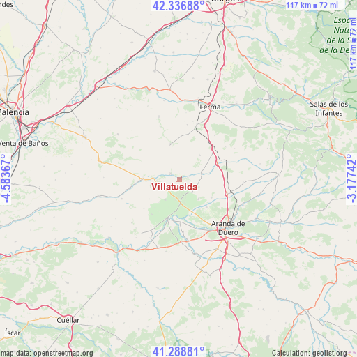
Villatuelda GPS coordinates[2]
41° 48' 53.964" North, 3° 52' 49.944" West
| Map corner | latitude | longitude |
|---|---|---|
| Upper-left | 42.33688°, | -4.58367° |
| Center: | 41.81499°, | -3.88054° |
| Lower-right: | 41.28881°, | -3.17742° |
| Map W x H: | 116.5×116.5 km | = 72.4×72.4mi |
| max Lat: | 43.74134° ⇑31.2% North |
| Villatuelda: | 41.81499° |
| min Lat: | ⇓68.8% South 27.64134° |
| min Long | Villatuelda | max Long |
| -18.00367° | -3.88054° | 4.2899° |
| W 42%⇐ | ⇒58% E |
Elevation
Elevation of Villatuelda is 862 m = 2828 ft, and this is 264 m = 866 ft above average elevation for this country.
| Max E: |
1682 m = 5518 ft | 23.7% |
| Villatuelda | 862 m 2828 ft | |
| Avg. | 598 m = 1962 ft | |
Min E: |
0 m = 0 ft | 76.3% |
See also: Spain elevation on elevation.city.
Geographical zone
Villatuelda is located in North temperate zone (between Tropic of Cancer and the Arctic Circle). Distance of this Northern Tropic circle is 2043.5 km =1269.8 mi to South.| Distance of | km | miles | from Villatuelda |
|---|---|---|---|
| North Pole | 5357.7 | 3329.1 | to North |
| Arctic Circle | 2751.8 | 1709.9 | to North |
| Tropic Cancer | 2043.5 | 1269.8 | to South |
| Equator | 4649.4 | 2889 | to South |


Nearby cities:
15 places around Villatuelda: (largest is in red/bold)
• Anguix
8 km =5 mi,  211°
211°
• Bahabón de Esgueva
13.5 km =8.4 mi,  67°
67°
• Berlangas de Roa
14 km =8.7 mi,  177°
177°
• Cabañes de Esgueva
7.8 km =4.8 mi,  77°
77°
• Cilleruelo de Abajo
10.3 km =6.4 mi,  41°
41°
• Olmedillo de Roa
5.7 km =3.5 mi,  231°
231°
• Oquillas
14.6 km =9.1 mi, 83°
• Pedrosa de Duero
14.4 km =8.9 mi,  218°
218°
• Quintana del Pidio
12.4 km =7.7 mi,  120°
120°
• Roa
13.7 km =8.5 mi,  196°
196°
• Sotillo de la Ribera
6.2 km =3.9 mi,  132°
132°
• Terradillos de Esgueva
3.1 km =1.9 mi, 82°
• Torresandino
2.9 km =1.8 mi,  303°
303°
• Tórtoles del Esgueva
11.9 km =7.4 mi,  270°
270°
• Villafruela
11.6 km =7.2 mi,  346°
346°
Sources, notices
• [Note1] Compared only with cities in Spain existing in our database
• [Src1] Map data: © OpenStreetMap contributors (CC-BY-SA)
• [Src2] Other city data from geonames.org with taken over terms of usage.
• [Src3] Geographical zone / Annual Mean Temperature by Robert A. Rohde @ Wikipedia
