Anguix geodata
Anguix (Castille and León) is a seat of a third-order administrative division; located in Spain in Europe/Madrid (GMT+2) time zone. With population of 138 people, there are 5518 cities with bigger population in this country. Compared to other cities in Spain, 67.4% of cities are located further ↓South; 58.7% of cities are located further →East and 70.2% of cities have lower elevation than Anguix. Note1


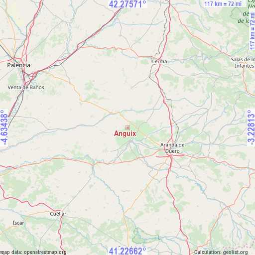
Anguix GPS coordinates[2]
41° 45' 11.916" North, 3° 55' 52.5" West
| Map corner | latitude | longitude |
|---|---|---|
| Upper-left | 42.27571°, | -4.63438° |
| Center: | 41.75331°, | -3.93125° |
| Lower-right: | 41.22662°, | -3.22813° |
| Map W x H: | 116.6×116.6 km | = 72.5×72.5mi |
| max Lat: | 43.74134° ⇑32.6% North |
| Anguix: | 41.75331° |
| min Lat: | ⇓67.4% South 27.64134° |
| min Long | Anguix | max Long |
| -18.00367° | -3.93125° | 4.2899° |
| W 41.3%⇐ | ⇒58.7% E |
Elevation
Elevation of Anguix is 815 m = 2674 ft, and this is 217 m = 712 ft above average elevation for this country.
| Max E: |
1682 m = 5518 ft | 29.8% |
| Anguix | 815 m 2674 ft | |
| Avg. | 598 m = 1962 ft | |
Min E: |
0 m = 0 ft | 70.2% |
See also: Spain elevation on elevation.city.
Geographical zone
Anguix is located in North temperate zone (between Tropic of Cancer and the Arctic Circle). Distance of this Northern Tropic circle is 2036.6 km =1265.5 mi to South.| Distance of | km | miles | from Anguix |
|---|---|---|---|
| North Pole | 5364.5 | 3333.3 | to North |
| Arctic Circle | 2758.6 | 1714.1 | to North |
| Tropic Cancer | 2036.6 | 1265.5 | to South |
| Equator | 4642.5 | 2884.7 | to South |


Nearby cities:
15 places around Anguix: (largest is in red/bold)
• Berlangas de Roa
8.6 km =5.3 mi,  145°
145°
• Castrillo de Don Juan
12.3 km =7.6 mi,  289°
289°
• Corrales de Duero
13.3 km =8.3 mi,  227°
227°
• Hoyales de Roa
12 km =7.5 mi, 151°
• Mambrilla de Castrejón
10.6 km =6.6 mi,  204°
204°
• Olmedillo de Roa
3.4 km =2.1 mi,  355°
355°
• Pedrosa de Duero
6.5 km =4 mi, 226°
• Roa
6.3 km =3.9 mi,  177°
177°
• San Martín de Rubiales
13.4 km =8.3 mi, 201°
• Sotillo de la Ribera
9.2 km =5.7 mi,  73°
73°
• Terradillos de Esgueva
10.3 km =6.4 mi,  45°
45°
• Torresandino
8.6 km =5.3 mi,  11°
11°
• Tórtoles del Esgueva
10.4 km =6.5 mi,  312°
312°
• Villaescusa de Roa
7.7 km =4.8 mi,  247°
247°
• Villatuelda
8 km =5 mi,  31°
31°
Sources, notices
• [Note1] Compared only with cities in Spain existing in our database
• [Src1] Map data: © OpenStreetMap contributors (CC-BY-SA)
• [Src2] Other city data from geonames.org with taken over terms of usage.
• [Src3] Geographical zone / Annual Mean Temperature by Robert A. Rohde @ Wikipedia
