Villarluengo geodata
Villarluengo (Aragon) is a seat of a third-order administrative division; located in Spain in Europe/Madrid (GMT+2) time zone. With population of 212 people, there are 4965 cities with bigger population in this country. Compared to other cities in Spain, 58.9% of cities are located further ↑North; 81.4% of cities are located further ←West and 94.2% of cities have lower elevation than Villarluengo. Note1


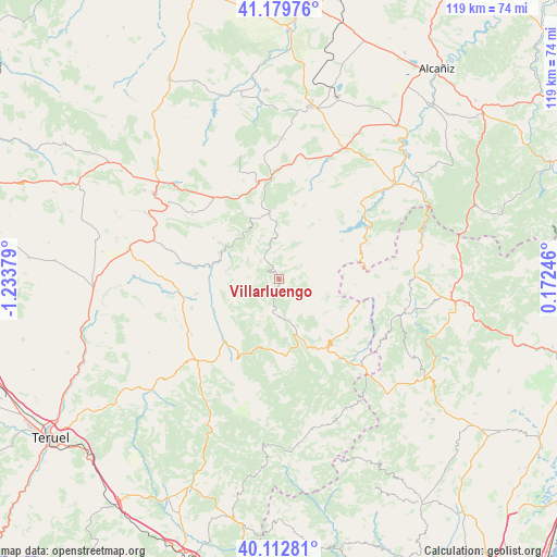
Villarluengo GPS coordinates[2]
40° 38' 54.312" North, 0° 31' 50.376" West
| Map corner | latitude | longitude |
|---|---|---|
| Upper-left | 41.17976°, | -1.23379° |
| Center: | 40.64842°, | -0.53066° |
| Lower-right: | 40.11281°, | 0.17246° |
| Map W x H: | 118.6×118.6 km | = 73.7×73.7mi |
| max Lat: | 43.74134° ⇑58.9% North |
| Villarluengo: | 40.64842° |
| min Lat: | ⇓41.1% South 27.64134° |
| min Long | Villarluengo | max Long |
| -18.00367° | -0.53066° | 4.2899° |
| W 81.4%⇐ | ⇒18.6% E |
Elevation
Elevation of Villarluengo is 1121 m = 3678 ft, and this is 523 m = 1716 ft above average elevation for this country.
| Max E: |
1682 m = 5518 ft | 5.8% |
| Villarluengo | 1121 m 3678 ft | |
| Avg. | 598 m = 1962 ft | |
Min E: |
0 m = 0 ft | 94.2% |
See also: Spain elevation on elevation.city.
Geographical zone
Villarluengo is located in North temperate zone (between Tropic of Cancer and the Arctic Circle). Distance of this Northern Tropic circle is 1913.8 km =1189.2 mi to South.| Distance of | km | miles | from Villarluengo |
|---|---|---|---|
| North Pole | 5487.4 | 3409.7 | to North |
| Arctic Circle | 2881.5 | 1790.5 | to North |
| Tropic Cancer | 1913.8 | 1189.2 | to South |
| Equator | 4519.7 | 2808.4 | to South |


Nearby cities:
15 places around Villarluengo: (largest is in red/bold)
• Aliaga
14.8 km =9.2 mi,  281°
281°
• Bordón
18.1 km =11.2 mi,  76°
76°
• Camarillas
19.3 km =12 mi,  258°
258°
• Cantavieja
17.2 km =10.7 mi,  142°
142°
• Cañada de Benatanduz
7.7 km =4.8 mi,  183°
183°
• Cañizar del Olivar
21 km =13 mi,  332°
332°
• Ejulve
14.4 km =8.9 mi,  352°
352°
• Fortanete
15.9 km =9.9 mi, 177°
• Gargallo
21.3 km =13.2 mi, 347°
• Mirambel
17.3 km =10.7 mi,  113°
113°
• Molinos
20.4 km =12.7 mi,  19°
19°
• Olocau del Rey
16.1 km =10 mi,  94°
94°
• Pitarque
5.3 km =3.3 mi,  270°
270°
• Tronchón
11.6 km =7.2 mi, 105°
• Villarroya de los Pinares
17.7 km =11 mi,  221°
221°
Sources, notices
• [Note1] Compared only with cities in Spain existing in our database
• [Src1] Map data: © OpenStreetMap contributors (CC-BY-SA)
• [Src2] Other city data from geonames.org with taken over terms of usage.
• [Src3] Geographical zone / Annual Mean Temperature by Robert A. Rohde @ Wikipedia
